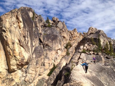
South Early Winter Spire/South Arête
A popular three or four pitch climb with a short approach, two 5.5 moves but mostly easy climbing, a real chockstone chimney, and great scrambling. Scenic views of Liberty Bell and the North Cascades. Snow melts off rock early so climb can be done shortly after Highway 20 is opened in the spring. Times: 5-7 hr trailhead to summit. A great first alpine rock climb.
getting there
Take Exit 232 (Cook Road) off of I-5 at Burlington, turning east to Sedro Wooley and SR-20. Continue on SR-20 to the Blue Lake Trailhead (5,200 ft), 1.5 mi west of the pass.
APPROACH
ASCENT ROUTE
The first pitch goes up a short steep crack. At this point, either go right and up (5.5, stretch across slab) to a small tree or go left across a short friction slab (5.5 finger traverse). Then easy climbing up to belay beneath the whitish south corner that splits the arête.
The second pitch climbs a gully becoming a chockstone chimney for 100 feet with a 5.4 move in the chimney. Belay at bolts above the chimney climbers' right of the tree. Note that in early June 2022, significant rockfall event in early June which left a lot of loose rock perched above the chock stone. A big thanks to North Cascades Mountain Guides for clearing the bigger pieces of the rockfall and adding the bolts. There's till bits that can come down, so be extra cautious!
Scramble up blocky section (some may want belay) and exit left and walk in coils up a long meandering sandy bench. Cross an exposed sharp ridgeline (belay or fixed-rope) and blocky terrain leading to top of southwest couloir. Beware of rockfall from above. Traverse into the top of the southwest couloir and ascend it to the top. Exit left and scramble to the summit.
DESCENT ROUTE
Hike down and rappel the climbing route. It can be done as two to three single rope rappels depending on how much is downclimbed.
TRIP PROFILE
| SEGMENT | TIME (HR) | ELEVATION GAIN (FT) |
|---|---|---|
| Trailhead to Summit | 5-7 | 2,600 |
| Summit to Trailhead | 3-4 |
EQUIPMENT
Standard rock equipment.
NOTES
- There was a significant rockfall event in early June which left a lot of loose rock perched above the chock stone. Larger rocks were removed, but there are plenty of smaller loose rocks still on route. If you choose to go up or down that way use cation. Read our blog post about the rockfall incident. A big thanks to North Cascades Mountain Guides for clearing the bigger pieces of the rockfall and adding the bolts. Watch their video of the rock removal.
- Do not ascend or descend the Southwest Couloir instead of the South Arête. This couloir goes just fine, but it has some loose rock in it, it is narrow, and very exposed to party-inflicted rockfall or to any rockfall from parties above, on the normal route.
- Basic students may lead some after the chockstone chimney if desired.
- Though many parties car camp at the trailhead the night before the climb, camping is NOT permitted here. There is good camping in Ross Lake National Recreation Area, an hour or so from the trailhead, as well as beyond Washington Pass in Okanogan National Forest.
- Hang packs and items left at the base of the climb away from the base to keep them protected from goats and from rockfall.
- This is a popular climb. Start early to beat the rush.
Information for LEADERS
Priority Climbs List
This is a very popular climbing route. Please check the PRIORITY CLIMBS LIST before listing trip to be sure your branch has priority for this route for the dates you plan to schedule it.
- Suitable Activities: Climbing
- Climbing Category: Basic Alpine
- Seasons: May, June, July, August, September, October
- Weather: View weather forecast
- View avalanche forecast.
- Difficulty: Basic Rock Climb, Strenuous 1, Technical 2, Basic Experience Climb
- Length: 6.0 mi
- Elevation Gain: 2,600 ft
- 7,807 ft
-
Land Manager:
Okanogan-Wenatchee National Forests
Methow Valley Ranger District (OWNF)
- Parking Permit Required: Northwest Forest Pass
- Recommended Party Size: 12
- Maximum Party Size: 12
- Maximum Route/Place Capacity: 12
- USGS Washington Pass
There are no resources for this route/place. Log in and send us updates, images, or resources.
