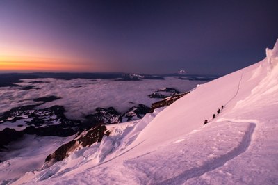
Mount Rainier/Disappointment Cleaver
Called the "DC Route," this is the most popular route to the summit of Washington state's highest mountain. Climb 9,000 feet on snowfields and glaciers. Travel a short distance on rock on the cleaver and possibly cross ladders. Enjoy a "top of the world" view from the summit. Many climbers on summer weekends often cause bottlenecks, and the altitude is an issue for many climbers. Times: 6-8 hr trailhead to camp, 5-8 hr camp to summit.
getting there
From SR-7 in Elbe, turn east onto SR-706, both known as the National Park Highway. Continue through the Nisqually Entrance of Mount Rainier National Park. Be prepared to pay the fee just after entering the park. Drive 19 miles to Paradise. Park in the overnight parking area.
APPROACH
Hike from Paradise (5,420 ft), take Skyline Trail and follow obvious tread past Panorama Point (6,800 ft) at 2.5 mi Route continues over Pebble Creek (7,200 ft) and up to Muir Snowfield to Camp Muir (10,080 ft), 2.7 mi from Panorama Point.
The compass bearing from Pebble Creek to Moon Rock is 350° true north, and 344° from Moon Rocks to Camp Muir. The reverse compass bearings are 170° and 164°, respectively.
ASCENT ROUTE
Disappointment Cleaver
Basic Glacier, Jun-Aug
From Camp Muir follow obvious traverse of the upper Cowlitz and scramble the Cathedral Rocks Ridge to gain access to the Ingraham Glacier (10,500 ft). Traverse the glacier (Ingraham Flats) to the lower southern base of Disappointment Cleaver. This traverse should be done as quickly as possible due to overhanging seracs. The route onto the Cleaver is approximately 300 ft above the Cleaver's nose.
Continue to the top of the Cleaver (12,300 ft), and climb as directly to the east crater rim as crevasses will allow. To gain the true summit, scramble down into the crater and cross directly to the west crater rim. The summit register is just below and northeast of the true summit (14,411 ft) by a large boulder.
INGRAHAM DIRECT
intermediate mountaineering, dec-apr
BASIC GLACIER CLIMB, May
During the winter, the standard route up Mount Rainier goes directly from the Cathedral Gap up the Ingraham Glacier towards the summit avoiding the chossy and avalanche-prone slopes of the Disappointment Cleaver. This route is more direct and shorter, but because of the large number of crevasses, it becomes uncrossable by the end of May. The exact path through the glacier changes from year to year. In the beginning of May, the route is typically wanded by the guiding companies, so there's an established bootpack and fixed protection (pickets, ladders, etc.). Prior to that, climbers must find their own way through the maze of crevasses.
From the Cathedral Gap, proceed west towards the Ingraham Icefall, then cross the icefall either by moving towards the top of the Disappointment Cleaver to join it at ~12,300 ft, or towards the top of the Gibraltar Rock at ~12,600 ft on up to 50° slopes. There are huge seracs overhanging the western portion of Ingraham Glacier at ~12,500 ft—move quickly through this section. After rejoining the Disappointment Cleaver route, continue on easier ground towards the summit.
DESCENT ROUTE
Descend the climbing route.
TRIP PROFILE
| SEGMENT | TIME (HOURS) | ELEVATION GAIN (FEET) |
|---|---|---|
| Seattle to Trailhead | 2.5 | |
| Trailhead to Camp | 6-8 | 4,460 |
| Camp to Summit | 5-8 | 4,330 |
| Summit to Camp | 2-3 | |
| Camp to Trailhead | 2-3 |
EQUIPMENT
Standard glacier equipment and helmet.
NOTES
- No camping is allowed in parking area; the nearest car camping available at Cougar Rock Campground.
- The public shelter at Camp Muir is usually packed. Plan on camping in tents.
- Be aware of rockfall danger on the Cleaver after June.
- Alternate base camp sites are located on the Muir Snowfield (just below Camp Muir) and on the Ingraham Flats (just above Cathedral Rocks Ridge).
- Treat or boil water at all camps.
- Be prepared to pack out all solid human waste.
- Excellent physical conditioning is mandatory.
- A smaller party size is recommended to minimize impact.
INFORMATION FOR LEADERS
PERMITS
A climbing permit is required for trips on glaciers and/or above 10,000 ft. Fees apply. Check with Mount Rainier National Park (land manger link below) to be sure you have the required camping and climbing permits.
Priority Climbs List
This is a very popular climbing route. Please check the PRIORITY CLIMBS LIST before listing trip to be sure your branch has priority for this route for the dates you plan to schedule it.
Multiple Bookings
Multiple books are allowed for this route/place, but all parties must have Climbing Permits from Mount Rainier National Park.
- Suitable Activities: Climbing
- Climbing Category: Basic Alpine
- Seasons: June, July, August
- Weather: View weather forecast
- Difficulty: Basic Glacier Climb, Strenuous 5, Technical 5, Basic Experience Climb
- Length: 15.0 mi
- Elevation Gain: 8,790 ft
- 14,411 ft
-
Land Manager:
Mount Rainier National Park
Mount Rainier Wilderness
- Parking Permit Required: National Park Entrance Fee
- Recommended Party Size: 12
- Maximum Party Size: 12
- Maximum Route/Place Capacity: 12
- USGS Mt Rainier East
- USGS Mt Rainier West
- Green Trails Mt Rainier West No. 269
- Green Trails Mt Rainier East No. 270
- Green Trails Mount Rainier Wonderland No. 269SX
There are no resources for this route/place. Log in and send us updates, images, or resources.
