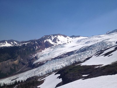
Heliotrope Ridge and Lower Coleman Glacier & Seracs
Heliotrope Ridge trail offers easy access to amazing glacier views on Mount Baker. The glaciated area is perfect for practicing glacier travel, crevasse rescue, and ice climbing if you have the gear and expertise.
getting there
From I-5 just north of Bellingham, drive east on SR-542 (Sunset Highway) to 1 mile east of Glacier. Turn right (south) on Forest Road 39 (Glacier Creek Road) and continue 9 miles to head of Mount Baker Trailhead (3,700 ft).
on the trail
Hike up Heliotrope Ridge Trail to the site of the old cabin. It's 5.5 miles round trip with 1,800 feet of elevation gain to a high point of 5,550 ft.
coleman glacier & seracs
From the cabin, follow climbers' trail (covered with snow early in the season) up the steep ridge to the moraine at the edge of the glacier. There are good camp spots on the edge of the moraine below 6,000 ft.
noteS
- There are many crevasses on this glacier.
- Forest Road 39 (Glacier Creek road) is susceptible to washouts.
Information for LEADERS
internal COURSE PRIORITY CALENDAR
- This is a very popular climbing area.
- Please review the 2025 Course Priority Calendar to ensure that either:
- Your field trip is listed on the calendar on the correct date and place -OR-
- No course has "reserved" that date and place, so there's room for your field trip.
- If the Coleman Seracs are available on the calendar, review the listed trips below before listing your trip to ensure there's no conflict
Scheduling & Permits
- Use this route/place for glacier travel, crevasse rescue, and ice climbing field trips on the lower section of the Coleman Glacier.
- If you are scheduling this as a non-course related activity, please limit your group size to the default party size. The maximum party size is for use by course field trips only, and includes both students and instructors. Group size maximums do not reflect how course field trips are run (in smaller groups of students and instructors), but allow for course leaders to register the course in our system.
- This route allows multiple bookings. Please check scheduled trips listed below in the "Activities" tab to see if there is another group already booked on the same day. If so, please coordinate with them to ensure you are carpooling and teaching at different areas. Our permit allows for a maximum of two groups per day with up to 12 people each.
- Suitable Activities: Climbing, Day Hiking
- Seasons: May, June, July, August
- Weather: View weather forecast
- Length: 5.5 mi
- Elevation Gain: 1,400 ft
-
Land Manager:
Mount Baker-Snoqualmie National Forest
Mount Baker Wilderness, Mount Baker Ranger District (MBSNF)
- Parking Permit Required: Northwest Forest Pass
- Recommended Party Size: 12
- Maximum Party Size: 12
- Maximum Route/Place Capacity: 24
- USGS Mt Baker
- Green Trails Mount Baker Wilderness Climbing No. 13SX
- Green Trails Mt Baker No. 13
This is a list of titles that represent the variations of trips you can take at this route/place. This includes side trips, extensions and peak combinations. Not seeing a title that fits your trip? Log in and send us updates, images, or resources.
- Heliotrope Ridge
- Mount Baker Lower Coleman Seracs & Glacier
There are no resources for this route/place. Log in and send us updates, images, or resources.
