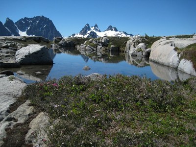
Necklace Valley
A very strenuous, 18-mile round trip day hike with 3,200 feet of elevation gain up the East Fork of the Foss River. The trail follows the East Fork Foss River through second growth forest. Extend your hike by heading right after campgrounds up a steep side stream to Jade Lake and beyond, or consider a scramble like Otter Point.
Getting There
From SR 2, about a half mile east of the Skykomish Ranger Station, turn south onto Forest Road 68, Foss River Road, and drive 4.1 miles to the East Fork Foss River Trailhead on the left (1,600 ft).
on the trail
This trail starts slow and easy, gaining just 600 feet in the first 5 mi through pleasant forest along the East Fork of the Foss River—a nice, moderate day hike. Then the work begins! As the trail crosses the river and climbs 2,400 feet in the next 3 mi. But oh the rewards! The first gem of a lake that the trail reaches is Jade, at 4,600 ft, then Emerald 0.25 mi farther, from which the chances for roaming are great - west to Jewel and Locket Lakes, east to Lake Ilswoot, or farther up to Opal and Cloudy Lakes under the steep cliffs of LaBohn Gap. There's great camping near Jade Lake, Lake Ilswoot, and Opal Lake.
Extending Your Trip
From the camp at the south end of Opal Lake, go off trail and up towards LaBohn, Chain and Williams Lakes and/or Fisher, Tank, and Bonnie Lakes. There are boot paths to follow, but off-trail navigation skills are a must.
Scramble routes
otter point (6,359 ft)
19 miles round trip with 4,800 feet of elevation gain
difficulty: strenuous 5, technical 3
From Opal Lake, the route heads WSW to ~5,800 ft, then traverses north to where it is feasible to head west to the ridge, then north to the summit. There are campsites at several of the lakes, but this area is getting very popular, so a weekend trip may not be advisable.
- Suitable Activities: Backpacking, Day Hiking, Scrambling
- Seasons: June, July, August, September, October
- Weather: View weather forecast
- Difficulty: Very Strenuous
- Length: 18.0 mi
- Elevation Gain: 3,200 ft
- 4,800 ft
-
Land Manager:
Mount Baker-Snoqualmie National Forest
Alpine Lakes Wilderness, Skykomish Ranger District (MBSNF)
- Parking Permit Required: Northwest Forest Pass
- Recommended Party Size: 12
- Maximum Party Size: 12
- Maximum Route/Place Capacity: 12
- Green Trails Alpine Lakes West (Stevens Pass) No. 176S
- Green Trails Skykomish No. 175
This is a list of titles that represent the variations of trips you can take at this route/place. This includes side trips, extensions and peak combinations. Not seeing a title that fits your trip? Log in and send us updates, images, or resources.
- Otter Point
There are no resources for this route/place. Log in and send us updates, images, or resources.
