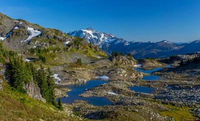
Yellow Aster Butte
A strenuous, 7.5 mile round trip day hike with 2,550 feet of elevation gain. The trail cuts up steeply, passing through a beautiful wild berry basin halfway up, and onto a prominent butte with panoramic views. Mount Baker, Mount Shuksan, Goat Mountain, and the views of the Picket Range are the highlights of this scenic hike.
Getting There
Drive SR-542 (Mount Baker Highway) to the Glacier Ranger Station. Continue on SR-542 13 miles and turn left (north) on Forest Road 3065 (Twin Lakes Road) and drive 4.7 miles to the Tomyhoi Lake/Yellow Aster Butte Trailhead (3,700 ft).
One the Trail
7.6 miles round trip, 2,550 feet of elevation gain, 6,150 ft high point
Hike the Tomyhoi Lake Trail to the fork at 5,050 ft. Turn left and follow the Yellow Aster Butte Trail until it wraps around Yellow Aster Butte to a tarn at at ~5,300.
Scramble Route
8.0 miles round trip, 2,800 feet of elevation gain, 6,241 high point
Difficulty: Strenuous 3, Technical 1
Hike the Tomyhoi Lake Trail to the fork at 5,050 ft. Turn left and follow the Yellow Aster Butte Trail until it wraps around Yellow Aster Butte to a tarn at at ~5,300. Hike the way trail to the right and ascend the butte to the ridge. Scramble along the north ridge to its ends and the summit (6,241 ft).
- Suitable Activities: Backpacking, Day Hiking
- Seasons: July, August, September, October
- Weather: View weather forecast
- Difficulty: Moderate/Strenuous
- Length: 7.5 mi
- Elevation Gain: 2,550 ft
- 6,150 ft
-
Land Manager:
Mount Baker-Snoqualmie National Forest
Mount Baker Wilderness, Mount Baker Ranger District (MBSNF)
- Parking Permit Required: Northwest Forest Pass
- Recommended Party Size: 12
- Maximum Party Size: 12
- Maximum Route/Place Capacity: 12
- Green Trails Mount Baker Wilderness Climbing No. 13SX
- Green Trails Mt Shuksan No. 14
- USGS Mount Larrabee
There are no resources for this route/place. Log in and send us updates, images, or resources.
