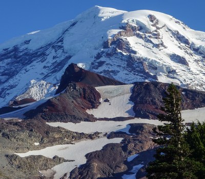
Observation Rock/North Face
Observation Rock via the North Face is a Grade II ice climb.
Getting there
From Buckley drive south on SR-165, eventually crossing the Carbon River bridge, to a road junction with the right, uphill fork signed for Mowich Lake. Take this right fork all the way to the lake (4,929 ft).
APPROACH
Follow the Spray Park Trail heading south from the lake. Shortly there will be a junction with the Wonderland Trail. Continue south, then east on the trail, up into Spray Park. Near the high point on the trail at approximately 6,400 ft a cairn marks a climber’s path which takes off north toward Observation Rock.
This path becomes indistinct around 7,200 ft in moraines. From here there are numerous ways to approach the North Face of Observation Rock by contouring southwest. Some parties aim for the small lake at 6,583 ft to ascend snow; this can reportedly avoid some tedious scree.
ASCENT ROUTE
Ascends the steep finger of the Flett Glacier, aiming southwest for Observation Rock’s summit. There is enough ice for four to five pitches, steepening to about 50° near the top. The first pitch is usually simul-climbed; then parties can swing leads to the top of the glacier. There is plenty of room for two to three parties to climb at once, with some variation in steepness and snow cover from left to right. From the top of the glacier, unrope and scramble to the crumbly summit for fine views of Rainier’s north side.
DESCENT ROUTE
The best descent is to scramble down to the south and east of Observation Rock. Descending to the west puts one back on the crevassed Flett Glacier which may prove impassable late in the season. Then follow the climbers’ trail back to Spray Park and then the main trail back to Mowich Lake.
TRIP PROFILE
| SEGMENT | TIME (HR) | ELEVATION GAIN (FT) | ELEVATION LOSS (FT) |
|---|---|---|---|
| Trailhead to Climb | 3-4 | 2,500 | |
| Climb to Summit | 2-3 | 800 | |
| Summit to Trailhead | 4-6 | 300 | 3,200 |
EQUIPMENT
Two ice tools, ice screws, pickets and crampons.
NOTES
- This climb is a rarity—it's a one-day ice climb.
- It must be done on or after July 1 for Intermediate Ice credit.
- The difficulty can vary greatly as conditions change. Trip leaders are asked to use judgement in awarding Intermediate Ice credit in conditions where it is unwarranted. Students should understand that achieving the summit does not guarantee credit. Characterizing a route on a given day as "challenging enough" is obviously subjective.
Information for Leaders
Permits
Check with Mount Rainier National Park (land manger link below) to be sure you have the required camping and climbing permits.
internal COURSE PRIORITY CALENDAR
- This is a very popular climbing area.
- Please review the 2025 Course Priority Calendar to ensure that either:
- Your field trip is listed on the calendar on the correct date and place -OR-
- No course has "reserved" that date and place, so there's room for your field trip.
- If Observation Rock is available on the calendar, review the listed trips below before listing your trip to ensure there's no conflict
- Suitable Activities: Climbing
- Climbing Category: Intermediate Alpine
- Seasons: July, August, September
- Weather: View weather forecast
- Difficulty: Intermediate Ice Climb
- Length: 13.0 mi
- Elevation Gain: 3,600 ft
- 8,364 ft
-
Land Manager:
Mount Rainier National Park
Mount Rainier Wilderness
- Parking Permit Required: National Park Entrance Fee
- Recommended Party Size: 12
- Maximum Party Size: 12
- Maximum Route/Place Capacity: 12
- USGS Mowich Lake
- USGS Mt Rainier West
- Green Trails Mount Rainier Wonderland No. 269SX
There are no resources for this route/place. Log in and send us updates, images, or resources.
