Trip
Backcountry Trail Run - Longs Pass & Lake Ingalls
A lake, Longs pass, and a lollipop loop - fall colors in the (usually!) sunny Teanaway.
- Sun, Oct 6, 2024
- Foothills Trail Running Committee
- Trail Running
- Adults
- Strenuous
- Moderate
- Mileage: 11.0 mi
- Elevation Gain: 4,100 ft
- Pace: 3.5 mph
- 2 (4 capacity)
- 1 (2 capacity)
- Sun, Sep 29, 2024 at 6:00 PM
- Sat, Oct 5, 2024 at 9:00 AM
- Cancellation & Refund Policy
- iCal Google
Clockwise loop - up to Ingalls Pass (+2000ft, 3miles), down to Lake Ingalls, short up out of the lake basin, down to Ingalls Creek (-1600ft, 2.4miles), up to Longs Pass (+1200ft, 1mile), final descent back down to trailhead (-1600ft, 2.5mi). Total: 10mi-11mi and ~3800ft gain, depending on what mapping app you use.
Pace: power hike uphill, run the flats and downs. This route has plenty of elevation gain, so expect it to be a slower pace of mostly hiking.
Gaia Route: https://www.gaiagps.com/map/?loc=12.6/-120.9228/47.4491&pubLink=LpvgmtPz1NeOeo2SQVJOnGyK&trackId=7356e7a6-4509-4a67-ab55-efda39268df2
8AM Eastgate Park & Ride (east side of the parking garage - here), Or 10:15AM Lake Ingalls Trailhead.
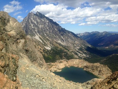
Lake Ingalls
-
Green Trails Alpine Lakes East (Stuart Range) No. 208SX
Green Trails Mt Stuart No. 209
USGS Mount Stuart - See full route/place details.
Required Equipment
- The Ten Essentials
- Sturdy running shoes
- headlamp
- water & snacks for 4 hours of movement
- wind breaker or similar warmer layer
- hat, gloves
