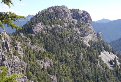
Arthur Peak
Arthur Peak is a winter scramble near the Carbon River in Mount Rainier National Park, with 3,470 feet of elevation gain. Most of the trip is in mossy old-growth forest, so in winter, it is relatively avalanche-safe terrain.
ASCENT ROUTE
Start at the Carbon River entrance gate. Hike the abandoned road for about 2 mi to the trail toward Green Lake. Follow this, leaving trail at 3,200 ft. Head west, picking up the lower slope of Rust Ridge. Climb heavily timbered hillside looking for a steep loose gully to attain the ridge. Make sure you mark spot where you came up for descent. Run the ridge south to the summit, no difficulties.
It is also possible to ascend the northwest ridge of Arthur directly from the road but this interesting variation requires good route finding skills and includes lots of brush and logs.
- Suitable Activities: Scrambling
- Seasons: Year-round, April
- Weather: View weather forecast
- View avalanche forecast.
- Difficulty: Winter Scramble, Rock Scramble, Snow Scramble, Strenuous 3, Technical 2
- Length: 10.0 mi
- Elevation Gain: 3,700 ft
- 5,465 ft
- Land Manager: Mount Rainier National Park
- Parking Permit Required: National Park Entrance Fee
- Recommended Party Size: 12
- Maximum Party Size: 12
- Maximum Route/Place Capacity: 12
- USGS Mowich Lake
There are no resources for this route/place. Log in and send us updates, images, or resources.
