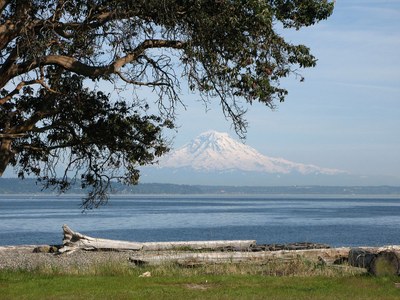
Blake Island
A beautiful 475-acre state park near Seattle reached by sea kayak, ferry or private boat. It has eight miles of hiking trails, and a four-mile loop trail around the island's waterfront offers spectacular views of the Seattle skyline, Mount Rainier, and the Olympic mountains. Black-tailed deer and bald eagles are commonly seen. Three beach campgrounds offer overnight accommodation. A nice outing when a sea kayak to the island and hike or backpack trip around the island are combined!
about the island
Blake island is one of the most scenic state parks in the Seattle region and an ancestral area of the Suquamish Tribe, whose Chief Seattle, the city’s namesake, was born. Nestled between Vashon and Bainbridge islands, this lesser known jewel is four miles from Alki Point, about a 45-minute ferry ride from Seattle.
- The 475-acre island park contains an eight-mile trail system. The main trail circumnavigates the island in a four-mile loop.
- Three beach campgrounds at the east, south, and west corners of the island provide campgrounds for overnight trips.
- The north corner of the island houses the marina and Tillicum village, which can get crowded during the summer tourist season. The rest of the island is highly underused even during peak season.
sea kayak Launch points
- Alki Beach in West Seattle
- Fort Ward on Bainbridge Island
- Illahee State Park near Bremerton
- Lincoln Park in West Seattle
- Manchester State Park
- Pomeroy Park in Manchester
- Port of Manchester
- Southworth Ferry Terminal near Bremerton
- Vashon Island
On the Water
Lincoln Park to Blake Island
difficulty: Sea Kayak IV
Illahee State Park to Blake Island
12 nm round trip, difficulty: sea Kayak III+
Fort Ward to Blake Island State Park
7.0 nm round trip 2.2 nm crossing, difficulty: sea kayak III+
Review the tides and plan accordingly, because there can be a brisk current in Rich Passage and around the northeast end of Blake Island. If crossing directly over to the northeast end of Blake Island consider swinging wide of higher current areas. It is also possible to paddle southwest across Rich Passage and along Manchester before doing the crossing so plan according to the wind, weather, and current. This route passes Orchard Rocks Conservation Area and a commercial fish farm.
Pomeroy Park to Blake Island
6.5 nm round trip, Difficulty: Sea Kayak II/III
Information For Leaders
Scheduling
Please only schedule one day hike or backpack and one sea kayak trip per day to minimize our impact on the island. Contact our Member Services Team if you have any questions.
permits
The Mountaineers has a commercial use permit with Washington State Parks for all free and fee-based outings at state parks. Leaders should carry a print or digital copy of our commercial use permit to show rangers they may encounter.
- Suitable Activities: Backpacking, Day Hiking, Sea Kayaking
- Seasons: Year-round
- Weather: View weather forecast
- Difficulty: Sea Kayak II
- Land Manager: Blake Island Marine State Park
- Parking Permit Required: Discover Pass
- Recommended Party Size: 12
- Maximum Party Size: 30
- Maximum Route/Place Capacity: 12
- MapTech Oak Bay to Commencement Bay No. 102
- NOAA Puget Sound: Seattle to Bremerton No. 18449
- Sea Trails Seattle, Bainbridge Island, Bremerton and Liberty Bay WA202
- USGS Duwamish Head
- USGS Bremerton East
This is a list of titles that represent the variations of trips you can take at this route/place. This includes side trips, extensions and peak combinations. Not seeing a title that fits your trip? Log in and send us updates, images, or resources.
- Blake Island Marine State Park
- Tillicum Village
- Lincoln Park to Blake Island
- Illahee State Park to Blake Island
- Fort Ward to Blake Island State Park
- Pomeroy Park to Blake Island
- Port of Manchester
There are no resources for this route/place. Log in and send us updates, images, or resources.
