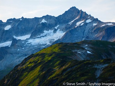
Forbidden Peak/West Ridge
This four-pitch 5.6, Grade II intermediate alpine rock climbs is one of the the 50 Classic Climbs in North America. Ice, snow, solid rock, and alpine scenery all blend together. This a very popular area is the starting point for many climbs, so permits are often difficult to obtain on summer weekends. Times: 3 hr to camp, 6-9 hr climb to summit.
getting there
Drive to Marblemount on SR-20. Register at the Marblemount Ranger Station. Take the Cascade River Road (Forest Road 15) for 21.7 miles to the Boston Basin Trailhead (3,200 ft), a pull out just before the Cascade Pass Trailhead.
APPROACH
The trail initially follows the old Diamond Mine roadbed for about 1 mile to where the trail leaves the road sharply right and steeply up. Follow trail to Boston Basin high camp on flats below glacier at about 6,500 ft. Alternate bivy sites exist at top of couloir.
ASCENT ROUTE
From Boston Basin campsite, cross glacier to prominent, 500 ft long couloir at the left edge of the South Face of Forbidden Peak. Ascend the steep snow- and ice-filled couloir to the crest of the West Ridge. Climb the exposed ridge on mostly solid rock via ledges and cracks. Difficulties are avoided by traversing on north side of ridge. Running belays speed the ascent.
DESCENT ROUTE
Descend climbing route. This may require belayed down-climbing and several single rope rappels along ridge, as well as rappels or step-kicking down couloir.
TRIP PROFILE
| SEGMENT | TIME (HOURS) | ELEVATION GAIN (FEET) |
|---|---|---|
| Trailhead to Camp | 3 | 3,300 |
| Camp to Summit | 6-9 | 2,300 |
| Summit to Trailhead | 8-10 |
EQUIPMENT
Standard rock gear, ice axe and crampons.
NOTES
- This climb is very popular and usually crowded. Boston Basin permits are frequently difficult to obtain.
- Snow often covers the rock until early July. Bergschrunds open up in couloir in late season and can be problematic. Rock routes exist on either side of the couloir.
- Many parties have had to bivy at the notch at the top of the couloir.
- Suitable Activities: Climbing
- Climbing Category: Intermediate Alpine
- Seasons: May, June, July, August
- Weather: View weather forecast
- Difficulty: Intermediate Rock Climb
- Elevation Gain: 5,600 ft
- 8,815 ft
-
Land Manager:
North Cascades National Park
Stephen Mather Wilderness
- Parking Permit Required: Northwest Forest Pass
- Recommended Party Size: 6
- Maximum Party Size: 12
- Maximum Route/Place Capacity: 12
- Green Trails Cascade Pass No. 80
- USGS Forbidden Peak
- Green Trails Diablo Dam No. 48
- USGS Cascade Pass
There are no resources for this route/place. Log in and send us updates, images, or resources.
