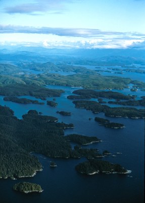
Broughton Archipelago Marine Park
Paddle through one of British Columbia Canada's largest marine parks that is home to dozens of undeveloped islands and islets near the north end of Vancouver Island. First Nation peoples have utilized this area for generations. Sea kayakers can easily find white midden beaches, culturally modified trees, clam terraces, an abundance of wildlife, and petroglyphs while exploring the park.
launch points
- Telegraph Cove
- Alder Bay
- Port McNeill
- Alert Bay
- Sointula
- Beaver Cove
- Port Hardy
on the water
Spend a few days to a week or more paddling through the Broughton Archipelago. A trip will likely include camping in unmaintained sites, paddling in currents up to 5 kts, winds up to 20 kts, up to 3 foot seas and 8 foot swell, and crossing shipping lanes with limited sight lines.
Information for Leaders
-
Considerations for travel to Canada
- Start by reviewing the latest regulations. Look for information on border crossing and travel to Canada on these websites:
- Everyone must have a passport or other valid ID like a NEXUS card.
- NEXUS cards can save a lot of time but only work if everyone in the car has one.
- Make sure your vehicle insurance is valid for Canada.
- Make sure your health insurance is valid for Canada.
- Border crossing regulations are strict in both directions. Know what you’re allowed to take and declare everything to avoid problems.
- You may be able to save time by checking alternate border crossings.
- See the Travel Industry Council of Ontario's 9 Travel Tips for Crossing the Canadian/U.S. Land Border blog post for some good tips on traveling to Canada.
- Start by reviewing the latest regulations. Look for information on border crossing and travel to Canada on these websites:
- Suitable Activities: Sea Kayaking
- Seasons: April, May, June, July, August, September
- Weather: View weather forecast
- Difficulty: Sea Kayak IV
- Length: 80.0 nm
- Land Manager: Broughton Archipelago Provincial Park
- Parking Permit Required: see "Launch Points" section (above)
- Recommended Party Size: 6
- Maximum Party Size: 12
- Maximum Route/Place Capacity: 12
- CHS No. 3546 - Broughton Strait
- CHS No. 3547 - Queen Charlotte Strait, Eastern Portion
- Wavelength Johnstone Strait and The Broughtons
This is a list of titles that represent the variations of trips you can take at this route/place. This includes side trips, extensions and peak combinations. Not seeing a title that fits your trip? Log in and send us updates, images, or resources.
- Broughton Archipelago
- Broughton Archipelago Provincial Park
- Johnstone Strait
- North Johnstone Strait
- Telegraph Cove
There are no resources for this route/place. Log in and send us updates, images, or resources.
