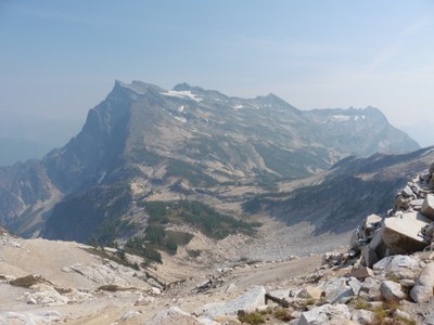
Buck Mountain/Southwest Route
At 8,528 ft, Buck Mountain in the Glacier Peak Wilderness is the 49th highest peak on Bulger list. The Southwest Route, 20 miles and 6,000 feet elevation gain, takes you from the Little Giant Trail to Napeequa Valley and up Louis Creek.
Approach & Ascent
On Chiwawa River Road, 1 mi past Nineteen Mile campground, cross the river and hike the Little Giant Trail over Little Giant Pass and drop down into the Napeequa Valley. Cross Lewis Creek 1.7 mi past the junction with Boulder Creek trail. Leave the trail here and hike up left side of creek through steep brush, past a waterfall, to nice basin at 6,400 ft. Ascend northeasterly to summit plateau. The middle summit is true summit, and is reached by ascending a Class 3 gully.
- Suitable Activities: Scrambling
- Seasons: April, May, June, July, August, September, October
- Weather: View weather forecast
- Difficulty: Technical 3, Strenuous 5
- Length: 20.0 mi
- Elevation Gain: 6,000 ft
- 8,528 ft
-
Land Manager:
Okanogan-Wenatchee National Forests
Glacier Peak Wilderness, Wenatchee River Ranger District (OWNF)
- Parking Permit Required: Northwest Forest Pass
- Recommended Party Size: 12
- Maximum Party Size: 12
- Maximum Route/Place Capacity: 12
- USGS Trinity
- USGS Clark Mountain
- Green Trails Holden No. 113
- Trails Illustrated Glacier Peak Wilderness
- Green Trails North Cascades Lake Chelan No. 114SX
There are no resources for this route/place. Log in and send us updates, images, or resources.
