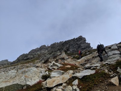
Cadet Peak
Cadet Peak is a prominent summit in the Monte Cristo area, with considerable technical challenge and a strenuous 8 mile approach. The old mining town of Monte Cristo and Glacier Basin, with the surrounding high summits, are well worth the visit.
getting there
From Granite Falls, drive the Mountain Loop Highway ~30 miles to Barlow Pass where the paving ends (2,360 ft). Parking is on the left.
Approach
Hike or mountain bike to Monte Cristo Campground (2,800 ft). The campground has a mountain bike rack for about 12 bikes.
ASCENT ROUTE
Hike the Glacier Basin Trail to 4,500 ft, where there is a large boulder (15 ft high). When the boulder is found, go left to another large boulder (20 ft high) across the basin and ascend small gully until 25 ft below a head wall. Then traverse left on rock ledges and up to trees/brush. Here a path that leads up to the left and to the ridge can be found. Follow path through scrub trees/brush to the ridge. Continue on ridge to about 6,800 ft, then go left across slope to the less steep slope west of the summit and ascend to summit.
NOTES
- Mountain bikes are recommended for travel to Monte Cristo. It's ~8 miles round trip. A day trip from Barlow Pass on foot makes for a very long and strenuous trip.
summit register
- As of July 2019, the Cadet Peak summit register has space for only a few more names on the inside of the back cover. If you're headed there, please contact our Member Services Team at info@mountaineers.org or 206-521-6001.
- Suitable Activities: Scrambling
- Seasons: June, July, August, September
- Weather: View weather forecast
- Difficulty: Strenuous 5, Technical 4
- Length: 16.0 mi
- Elevation Gain: 5,000 ft
- 7,186 ft
-
Land Manager:
Mount Baker-Snoqualmie National Forest
Darrington Ranger District (MBSNF)
- Parking Permit Required: Northwest Forest Pass
- Recommended Party Size: 8
- Maximum Party Size: 12
- Maximum Route/Place Capacity: 12
- USGS Blanca Lake
There are no resources for this route/place. Log in and send us updates, images, or resources.
