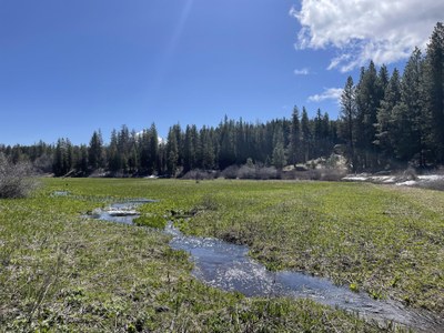
Camas Meadows
An easy, two-mile hike on meandering trails, with less than 350 ft of elevation gain. The meadows are a seasonal wetland in the Wenatchee Mountains, a Washington Natural Area Preserve with a fragile ecosystem and endemic plants. Please tread lightly!
Getting There
From SR- 97, 5 miles south of SR-2 and 37 miles north of Cle Elum, turn east onto Camas Creek Road. Drive 3.1 miles to the meadow and a fork in the road. Take the left fork and drive 0.25 mile to the parking area and gate in the road.
On the Trail
Camas Meadows, also know as Camas Land, is a flat meadow surrounded by ponderosa pine. It melts out late, and is often under snow and water in April and into May. The best known plants are the checker mallow (Sidalcea oregana) and Wenatchee larkspur (Delphinium viridescens).
Notes
- A plant list is available on the Washington Native Plant Society website's Plant Lists.
- Suitable Activities: Day Hiking, Naturalist, Urban Walking
- Seasons: April, May, June, July, August, September, October, November
- Weather: View weather forecast
- Difficulty: Easy
- Length: 2.0 mi
- Elevation Gain: 350 ft
- 3,200 ft
- Land Manager: Washington State Department of Natural Resources
- Parking Permit Required: Discover Pass
- Recommended Party Size: 8
- Maximum Party Size: 12
- Maximum Route/Place Capacity: 12
- Green Trails Liberty No. 210
This is a list of titles that represent the variations of trips you can take at this route/place. This includes side trips, extensions and peak combinations. Not seeing a title that fits your trip? Log in and send us updates, images, or resources.
- Camas Meadows Preserve
- Camas Land
There are no resources for this route/place. Log in and send us updates, images, or resources.
