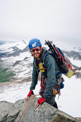
Sahale Peak/South Slope
An easy 3.5 mi trail leads to Cascade pass, then head east, up Sahale Arm for another 1,700 feet of gain to camp on the Sahale Glacier. Views down the Stehekin valley and into the heart of the North Cascades, and great sunrises/sunsets from camp. Watch for rockfall during the descent from the summit. Times: 4-5 hr trailhead to camp, 2 hr camp to summit.
getting there
Take I-5 to just north of Mount Vernon, then go east on SR 20 (North Cascades Highway) to Marblemount. Sign in at Ranger Station and get permit if not planning to car camp. Continue on the Cascade River Road (Forest Road 15) and follow it 23.5 miles to a parking area and trailhead at road's end (3,600 ft).
APPROACH
Follow the Cascade Pass Trail 3.5 miles to Cascade Pass (5,392 ft). From Cascade Pass ascend Sahale Arm to ~7,000 ft.
ASCENT ROUTE
Ascend north-northeast across Sahale Glacier to the rock slabs on the south side of the summit. Climb southeast corner of the summit block, mostly Class 3 with a short Class 4 section. Alternative: Traverse high around east side (exposed), ascend broken rock on north side.
DESCENT ROUTE
Descend the climbing route. One long runner needed for a 100 ft rappel. Watch for rock fall on descent. The rappel from summit should be made to the south side where the rock strata slopes away and is relatively free of loose rock.
TRIP PROFILE
| SEGMENT | TIME (HR) | ELEVATION GAIN (FT) |
|---|---|---|
| Seattle to Trailhead | 3 | |
| Trailhead to Camp | 4-5 | 4,000 |
| Camp to Summit | 2 | 1,100 |
| Summit to Camp | 2 | |
| Camp to Trailhead | 3-4 |
EQUIPMENT
Standard rock and glacier equipment, including helmet and extra water.
NOTES
Camping is allowed only above the second moraine on the Sahale Glacier, at 7,600 ft. Check with the Ranger 30 days in advance about reserving a camp site. If going early or in a heavy snow year, call the Ranger Station to see how far the road is open.
Because this area sustains heavy use, this climb can be done in one long day from the parking lot, but by doing so you miss the spectacular view of sunset and sunrise from camp on the Sahale Glacier.
- Suitable Activities: Climbing
- Climbing Category: Basic Alpine
- Seasons: July, August, September, October
- Weather: View weather forecast
- Difficulty: Basic Alpine Climb, Strenuous 3, Technical 1, Basic Experience Climb
- Length: 17.0 mi
- Elevation Gain: 5,300 ft
- 8,680 ft
-
Land Manager:
North Cascades National Park
Stephen Mather Wilderness
- Parking Permit Required: None
- Recommended Party Size: 12
- Maximum Party Size: 12
- Maximum Route/Place Capacity: 12
- Green Trails Cascade Pass No. 80
- USGS Cascade Pass
This is a list of titles that represent the variations of trips you can take at this route/place. This includes side trips, extensions and peak combinations. Not seeing a title that fits your trip? Log in and send us updates, images, or resources.
- Sahale Peak via Sahale Arm
There are no resources for this route/place. Log in and send us updates, images, or resources.
