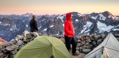
Cascade Pass & Sahale Arm
A strenuous, 12 mile hike with up to 4,200 feet of elevation gain to Sahale Arm. Starting with views of Johannsburg Mountain, the trail climbs 3.7 miles to Cascade Pass (5,400 ft), a vista of flower meadows and more ice covered peaks before, continuing on to Sahale Arm. Consider visiting Doubtful Lake, a short side trip form Cascade Pass, or extending your trip to Horseshoe Basin.
getting there
From Marblemount on SR 20, drive the Cascade River Road 23 miles to its end and the Cascade Pass Trailhead (3,600 ft).
on the trail
Cascade Pass & Sahale Arm
Up to 12 miles round trip with 4,000 feet of elevation gain
Hike 3.7 miles, climbing 1,400 feet in the first 2 miles, to Cascade Pass (5,400 ft). Take the left fork to ascend Sahale Arm as far as you'd like to go. Shahale Glacier Camp (7,600 ft), also known as Sahale High Camp, is 2.2 miles from the pass. Consider a side trip 1 mile and 800 feet down to Doubtful Lake, shortly after leaving Cascade Pass.
Horseshoe Basin via Cascade Pass
18 miles round trip with 4,600 feet of elevation gain
From the trailhead, climb the trail to Cascade Pass. From Cascade Pass, head southeast descending into the Pelton Basin, and crossing Doubtful Creek after a series of downhill switchbacks. Continue east to a junction and follow the trail straight ahead eventually turning north paralleling Basin Creek up into Horseshoe Basin. Numerous waterfalls cascade down the walls of the basin and there is good wildlife viewing including marmots, deer, and chipmunks and perhaps the occasional black bear. Venture further up into the basin to the entrance to the now-defunct Black Warrior mine which is marked by a small plaque. No barriers prevent entry, but the Park Service discourages people from entering. Flooded chambers, heaps of rockfall, unpredictable oxygen levels, and rotting timbers supporting unstable rock make the inside an unsafe place to explore.
- Suitable Activities: Backpacking, Day Hiking
- Seasons: July, August, September, October
- Weather: View weather forecast
- Difficulty: Strenuous, Very Strenuous
- Length: 12.0 mi
- Elevation Gain: 3,600 ft
- 7,200 ft
- Land Manager: North Cascades National Park
- Parking Permit Required: None
- Recommended Party Size: 12
- Maximum Party Size: 12
- Maximum Route/Place Capacity: 12
- Green Trails Cascade Pass No. 80
- USGS Cascade Pass
This is a list of titles that represent the variations of trips you can take at this route/place. This includes side trips, extensions and peak combinations. Not seeing a title that fits your trip? Log in and send us updates, images, or resources.
- Cascade Pass
- Cascade Pass & Doubtful Lake
- Sahale Arm
- Sahale Glacier Camp
- Sahale High Camp
- Horseshoe Basin via Cascade Pass
There are no resources for this route/place. Log in and send us updates, images, or resources.
