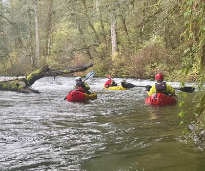
Cedar River: Landsberg to Lake Washington
A fun, active Class 2 whitewater packraft near Maple Velley and Renton.
Flow
- NOAA Gauge: CEDAR--NEAR LANDSBURG (LNDW1)
- 400 - 600 cfs: An active run to avoid boulders and shallow spots.
- 600 - 1,200 cfs: A fast and smoother run, about a 4-5 mph relaxed pace.
- NOAA Gauge: CEDAR--AT RENTON (RNTW1)
Put-Ins & Take-Outs
- Landsberg Bridge: On the northwest side of the Landsberg bridge is a large parking area.
- Fred V Habenicht Rotary Park: In Maple Valley, on the southeast side of the Renton-Maple Valley Rd bridge.
- Belmondo Reach Natural Area: has a dirt parking area and easy trails to the river. There may be a porta potty.
- Cedar River Park: There are multiple access points at this large park. The Henry Moses Aquatic Center has a large parking area and beach access to the Cedar River.
- Cedar River Trail Park at Lake Washington has parking and river access.
On The River
Flow on the Cedar River is dam controlled. The dam creates the Chester Morris Lake, a water supply to the city of Seattle. Because it is dam controlled, flow rates on the Cedar River are somewhat modulated by decisions on how much water is released from the dam. At 400 cfs on the Landsburg gauge this is an active run with many boat handling challenges, including rocks to bump over, but never very difficult.
Landsberg to Fred V Habenichts Rotary Park
7.5 miles
This is the most active section of the river, with frequent call for boat handling, though none very difficult. Just upstream of the Landsberg Bridge is a white water slalom course. This consists of gates that must be paddled through in specific sequence and direction. When not used, the gates are raised well above the river area. Walk upstream and launch above this Class 2 rapid.
Fred V Habenichts Rotary Park to Belmondo Reach Natural Area
5 miles
Below Maple Valley, the river mellows. It is more common to have longer stretches of straight forward paddling.
Belmondo Reach Natural Area to Lake Washington
9.5 miles
The river continues to slow. There are several parks along the river.
Notes
- This river section is part of the Cedar River -Lake Washington Watershed, managed by King County.
- Wood hazard is common and there are some warning signs. Don't let the possibility of wood deter you from this fun run, but do be alert to it.
- As of Nov 2022 and Just below the third railroad bridge (47.3948,-122.03228), a major new wood hazard exists river wide that must be portaged; portage right.
- The American Whitewater Cedar River Landsburg Bridge to Maplewood Roadside Park covers most of this river section.
- Suitable Activities: Packrafting
- Seasons: January, February, March, April, May, June, October, November, December
- Weather: View weather forecast
- Difficulty: Class II River
- Length: 22.0 mi
- 538 ft
- Land Manager: Land Manager Varies
- Parking Permit Required: see Land Manager
- Recommended Party Size: 12
- Maximum Party Size: 12
- Maximum Route/Place Capacity: 12
This is a list of titles that represent the variations of trips you can take at this route/place. This includes side trips, extensions and peak combinations. Not seeing a title that fits your trip? Log in and send us updates, images, or resources.
- Cedar River: Landsburg to Maple Valley
- Cedar River: Maple Valley to Renton
- Cedar River: Maple Valley to Lake Washington
There are no resources for this route/place. Log in and send us updates, images, or resources.
