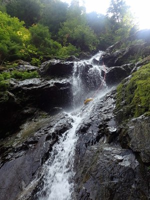
Change Creek
A nice creek with rapid fire rappels located close to North Bend. This canyon is rated v3a3II at normal water levels.
GETTING THERE
Take Exit 38 off of I-90 in North Bend. Turn north and then continue straight (do not turn right again into the Olallie State Park parking lot). Park in the dirt climber's parking area on the left.
APPROACH
Hike the trail that is across from the parking area and just to the right of the bridge that crosses over Change Creek. Follow this trail as it passes under the Palouse to Cascades State Park Trail (formerly known as the John Wayne Trail or Iron Horse Trail). Continue to follow the trail as it parallels the creek—avoid the climbers' spur trails. As the trail becomes less distinct, look for orange flagging. This area sees a lot of blow-down in the winter, so its likely that spots of the trail will be blocked. It is well-flagged, so take care to follow the orange flags. If you go more than a few hundred feet without seeing a flag, head back to your last flag and try again. The approach is a little more than a mile, and will take about 45 minutes. The flags lead directly to the top of the first rappel.
DESCENT
Change Creek has 6-8 rappels, depending on how they are rigged. Although this creek can have a lot of wood, its quite beautiful. Be aware that the rock and wood can be incredibly slippery. The rock in this creek is sharp, so be sure to use techniques like directionals, bag padding, and rope creeping to reduce abrasion on your rope.
- Rappel 1: 30 ft (10 m) from a boulder DCR (Down Canyon Right) into shallow pool. A fixed deviation/directional is available on a tree DCR just below the rappel anchor, the use of which will help avoid rope abrasion.
- Rappel 2: 40 ft (12 m) from small tree DCR.
- Rappel 3: There are two options: one single 140 ft (43 m) rappel from the root ball of a huge fallen tree DCR in two stages (pull angle from bottom is good), or two separate rappels, pulling the rope at the bottom of stage 1, and using a fallen log as an anchor for Stage 2. If splitting into two rappels, be careful to manage your rope on the second stage for the pull, which can be tricky over a rounded slab. The pull of stage 2 is best from DCR.
- Stage 1: 45 feet (14 m) to shallow pool.
- Stage 2: 95 feet (29 m) down a cascade.
- Rappel 4: 105 feet (31m) from bolts DCR. Bolts are exposed & a hand line is strongly recommended. A hand line anchor is set on a log about 30 feet (10m) back from the bolts (note that a 60m rope is not long enough for this rappel.
- Note: During higher flow canyoners may choose to rappel out of the flow off one of the logs on to a ledge DCL, then rig off of the logs on the ledge, as noted below.
- R4a: 15 ft (5 m) from fallen log DCL to a large ledge with several trees.
- R4b: 120 ft (37 m) from one of the trees on the ledge.
- Note: During higher flow canyoners may choose to rappel out of the flow off one of the logs on to a ledge DCL, then rig off of the logs on the ledge, as noted below.
- Downclimb a small cascade.
- Rappel 5: 45 feet (14 m) from large tree DCR. This anchor is also exposed and a hand line from a nearby tree is recommended.
- Downclimb a small cascade.
- Rappel 6: 100 feet (12 m) from tree DCR, dropping to a low angle slab leading to a narrow chute next to fallen log, or downclimb mossy rock DCL.
EXIT
After the final chute rappel, pack up your rope and head downstream. The amount of creek walking will depend on how quickly you spot access to a trail. After about 5-10 minutes of creek walking, its possible to scramble up to a trail on the left, which leads to the main trail and out to the road. The exit is 20-30 minutes in total.
EQUIPMENT
Standard canyoning gear including replacement webbing and quick links. A hand line is useful.
TRIP PROFILE
- Rappels: 6-8
- Longest Rappel: 105 feet
- Approach: ~1 mile
- Exit: ~0.5 mile
- Time: 6-8 hours total
NOTES
- This canyon is rated v3a3II at moderate-low water levels, and v3a4II in early to mid-season.
Information for Leaders
Scheduling
This route allows multiple bookings. Please check scheduled trips listed below in the "Activities" tab to see if there is another group already booked on the same day. Leaders are expected to contact the leader(s) of existing trips to ensure there are no concerns or conflicts, according to The Mountaineers Outdoor Ethics Policy. Please review our Group Size & Multiple Bookings page for guidance.
PermitS
As of 2017, the Snoqualmie Ranger District considers Mountaineers trips and courses to be "nominal use". Leaders should print and copy this designation letter to show rangers they may see on trail or carry a digital copy on their phone.
- Suitable Activities: Canyoning
- Seasons: April, May, June, July, August, September, October
- Weather: View weather forecast
- Difficulty: Basic Canyon
- Length: 2.0 mi
- Elevation Gain: 900 ft
-
Land Manager:
Mount Baker-Snoqualmie National Forest
Snoqualmie Ranger District (MBSNF)
- Parking Permit Required: Northwest Forest Pass
- Recommended Party Size: 6
- Maximum Party Size: 12
- Maximum Route/Place Capacity: 12
- Green Trails Mount Si NRCA No. 206S
| Name/Description |
|---|
| Change Creek Ropewiki Link Ropewiki link for Change Creek |
