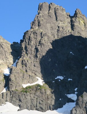
Chimney Rock/East Face Direct
A challenging Grade II, 5.6 intermediate-level alpine rock climb in the Alpine Lakes Wilderness. It's 16 miles round trip with 4,900 feet of elevation gain.
getting there
Take Exit 80 (Roslyn/Salmon la Sac) off of I-90. Turn left (north) on SR 903/Salmon la Sac Road and continue 16.8 miles through Roslyn and past Cle Elum Lake. Turn left (west) on Forest Road 46 and follow 4.7 miles. Turn right on Forest Road 4616 and continue 1 mile to the trailhead (2,900 ft).
Approach
Follow the trail to Pete Lake and continue to the Pacific Crest Trail (PCT). Follow PCT north about a mile to an avalanche path with large blowdowns crossing the trail near confluence of creek from Chimney Glacier. Leave the PCT, work across the avalanche path to the right side of “Chimney Creek,” and locate climber’s trail. In about 200 yards, the trail crosses to creek’s left, recrossing back right a half mile further, where it remains until the Chimney Glacier moraine is reached. Descend 200 feet to the lower Chimney Glacier. Rope up and ascend the lower glacier. Three options are available to gain the upper glacier. Most common is via the rock or snow gully in cliff leading to upper glacier just left of ice fall. Alternately, a snow finger on the far left can be used, or the icefall can be climbed directly if conditions and gear (ice tools, ice screws, and crampons) are suitable. Once on upper glacier, ascend to east face of the main peak of Chimney Rock directly beneath summit where a moat often forms.
Ascent
Climb one pitch up from glacier to broad heather ledge system and possible bivy site. At the right side of the ledge system, climb another leftward sloping ledge system to faces and gullies towards the north end (right side) of the prominent key ledge two-thirds up the face. Bivy at “Key Ledge” (~4 hours from the glacier) with space for about 6 people, but questionable water. From the ledge climb three pitches to the summit (~2½ hours from bivy ledge).
DESCENT ROUTE
Two rappels return to “Key Ledge.” Two options are available from here. (1) Make six rappels down to glacier (good anchors reported all the way). (2) Descend the “normal” East Face route by traversing to the notch between the main and south peaks and then scrambling south, traversing down onto the east face of south peak until grassy ledges can be followed down. One rappel is needed to reach same level as heather incline. Traverse over to East Face Direct route and make one rappel back to glacier (~4½ hours from summit).
TRIP PROFILE
| SEGMENT | TIME (HR) | ELEVATION GAIN/Loss (FT) | |
|---|---|---|---|
| Trailhead to Camp | 15 | +4,500 | |
| Camp to Summit | 3 | +400 | |
| Summit to Trailhead | 10-12 | -4,900 |
Gear
Ice axe, crampons, glacier gear, and medium alpine rock rack.
NOTES
- Consider planning as a three-day climb. Many parties plan the climb for two days but end up taking a third. Without efficient movement or early start, “Key Ledge” will not be reached before dark, requiring a longer second day or second bivy before returning to cars.
- While not technically difficult, this large face has an exposed feel and can be difficult to protect in places.
Photo taken by Rob Busack on July 9, 2017.
- Suitable Activities: Climbing
- Climbing Category: Intermediate Alpine
- Seasons: June, July, August, September
- Weather: View weather forecast
- View avalanche forecast.
- Difficulty: Intermediate Rock Climb
- Length: 16.0 mi
- Elevation Gain: 4,900 ft
- 7,860 ft
-
Land Manager:
Mount Baker-Snoqualmie National Forest
Alpine Lakes Wilderness, Snoqualmie Ranger District (MBSNF)
- Parking Permit Required: Northwest Forest Pass
- Recommended Party Size: 6
- Maximum Party Size: 12
- Maximum Route/Place Capacity: 12
- USGS Big Snow Mtn
- USGS Chikamin Peak
- USGS Polallie Ridge
There are no resources for this route/place. Log in and send us updates, images, or resources.
