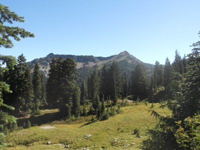
Tahtlum Peak
Tahtlum is a moderate scramble south of Chinook Pass, 4 miles and 1,400 feet of elevation gain.
Getting there
Park at the day use area at the foot of Yakima Park located east of Chinook Pass along Highway 410.
APPROACH AND ASCENT
Take the Pacific Crest Trail south until you reach the high point between Naches Peak and Tahtlum Peak. Look for the bootpath on the left, there are a few that cross eachother before becoming more firmly established which will take you to the base of Tahtlum Peak. The route leads towards the more exposed north side (but never more than 40 degrees). The bootpath goes in and out as you continue to climb up to the true summit where you can find views of of Mount Rainier, Mount Adams, Mount Saint Helens, Crystal Mountain, and even Mount Stuart.
FOr leaders
Permit information
As of 2017, the Snoqualmie Ranger District considers Mountaineers trips and courses to be "nominal use". Leaders should print and copy this designation letter to show rangers they may see on trail or carry a digital copy on their phone.
- Suitable Activities: Scrambling
- Seasons: April, May, June, July, August, September, October
- Weather: View weather forecast
- Difficulty: Technical 3, Strenuous 2
- Length: 6.0 mi
- Elevation Gain: 1,600 ft
- 6,567 ft
-
Land Manager:
Mount Baker-Snoqualmie National Forest
Snoqualmie Ranger District (MBSNF)
- Parking Permit Required: Northwest Forest Pass
- Recommended Party Size: 12
- Maximum Party Size: 12
- Maximum Route/Place Capacity: 12
- USGS Chinook Pass
- USGS Cougar Lake
There are no resources for this route/place. Log in and send us updates, images, or resources.
