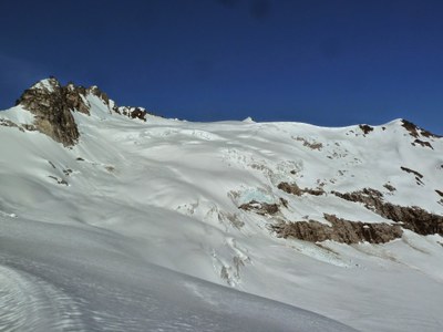
Clark Mountain & Luahna Peak
Climbing one or two glaciated peaks southeast of Glacier Peak, Beginning with a flat four mile hike the approach hike takes you to Boulder Pass that overlookis the Napeequa Valley. Overshadowed by its neighbor, Clark Mountain, Luahna Peak offers a more remote, alpine feel with the same approach, but a more complicated route to its summit.
getting there
Drive US 2 (Stevens Pass Highway) to the Lake Wenatchee turn-off (Coles Corner, 20.3 mi east of Stevens Pass). Turn north on Lake Wenatchee River Road (SR 207); bear left after crossing the Wenatchee River, proceeding west along the north shore of the lake passing the Lake Wenatchee Ranger Station. About 1.5 mi after the ranger station, take the right fork—White River Road (Forest Road 6400), to the end of the road (about 11 mi).
Approach
Travel the mainly level and easy White River Trail 4 mi to the junction with Boulder Creek Trail (.25 mi past the bridge over Boulder Creek). Ascend Boulder Creek trail. At 4,000 ft, the trail crosses Boulder Creek. Either wade the creek or use small tree. Continue up trail to suggested campsite at edge of clearing in large open basin at 4,900 ft (7.5 mi).
There is an alternate base camp at 6,000 ft (8.5 mi), just below Boulder Pass.
ASCENT ROUTE
clark mountain/walrus glacier
Find Boulder Pass Trail north of campsite and ascend toward Boulder Pass. At 5,800 ft, climb directly up fall line to left side of pass (1.5 hr). From left side of pass, climb 50 ft up ridge toward Peak 7242, then follow a rising traverse across the basin east of Peak 7242 crossing the northeast ridge at 6,700 ft. Turn west and traverse toward glacier (30 minutes).
Climb with rising traverse from bottom south edge (left) of glacier towards center of glacier. Ascend up and slightly left to miss large crevasse, then head west (right) to large basin at 7,600 ft. Head west-northwest toward false summit. Cross ridge south of false summit and traverse slope to major gully. Ascend gully to ridge and follow ridge west to summit.
Luahna Peak/Richardson Glacier
Find Boulder Pass Trail north of campsite and ascend toward Boulder Pass. At 5,800 ft, climb directly up fall line to left side of pass (1.5 hr). From left side of pass, climb 50 ft up ridge toward Peak 7242, then follow a rising traverse across the basin east of Peak 7242 crossing the northeast ridge at 6,700 ft. Turn west and traverse toward glacier (30 minutes).
Climb with rising traverse from bottom south edge (left) of glacier towards center of glacier. Ascend up and slightly left to miss large crevasse, then head west (right) to large basin at 7,600 ft. Contour westerly under the North side of the summit of Clark Mountain, and cross the ridge northwest of Clark, between Point 7970 and Clark Mountain. Traverse west under Point 7970, cross its southwest ridge then head north to a col. From here drop to the Richardson Glacier and bear north to the East Ridge of Luahna. Scramble west to the summit. Alternatively you may avoid the Richardson Glacier completely and scramble the South Ridge of Luahna to its summit.
Descent Route
clark mountain/walrus glacier
Descend the climbing route if there is enough snow. Otherwise, from upper basin on glacier (7,600 ft), head southeast to first notch east of Peak 8373. From notch (7,720 ft) descend steep snow slope in gully. Once out of gully, make a descending traverse left to 6,500 ft. Traverse south across slope and find major gully system leading to basin. Descend south side of gully to top of cliffy area. Cross gully with stream and descend into basin to lower campsite.
Luahna Peak/Richardson Glacier
Descend the climbing route if there is enough snow. Otherwise, from upper basin on the Walrus glacier (7,600 ft), head southeast to first notch east of Peak 8373. From notch (7,720 ft) descend steep snow slope in gully. Once out of gully, make a descending traverse left to 6,500 ft. Traverse south across slope and find major gully system leading to basin. Descend south side of gully to top of cliffy area. Cross gully with stream and descend into basin to lower campsite.
Route Profile
Clark Mountain/Walrus Glacier
Luahna Peak/Richardson Glacier
EQUIPMENT
Standard glacier equipment.
NOTEs
- The glacier breaks up by late July.
- Be prepared to fight off black flies at base camp.
- Bring footwear (sandals?) and a pole for the creek crossing.
- Suitable Activities: Climbing
- Climbing Category: Basic Alpine
- Seasons: June, July, August
- Weather: View weather forecast
- Difficulty: Basic Glacier Climb, Strenuous 4, Technical 2, Basic Experience Climb
- Length: 22.0 mi
- Elevation Gain: 6,300 ft
- 8,602 ft
-
Land Manager:
Okanogan-Wenatchee National Forests
Glacier Peak Wilderness, Wenatchee River Ranger District (OWNF)
- Parking Permit Required: Northwest Forest Pass
- Recommended Party Size: 12
- Maximum Party Size: 12
- Maximum Route/Place Capacity: 12
- Green Trails Holden No. 113
- USGS Clark Mountain
This is a list of titles that represent the variations of trips you can take at this route/place. This includes side trips, extensions and peak combinations. Not seeing a title that fits your trip? Log in and send us updates, images, or resources.
- Clark Mountain/Walrus Glacier
- Luahna Peak/Richardson Glacier
There are no resources for this route/place. Log in and send us updates, images, or resources.
