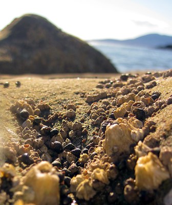
Clayton Beach
From Wildcat Cove in Larrabee State Park, hike south long Clayton Beach on the shore of Samish Bay west of the Chuckanut Mountains. Enjoy honeycombed sandstone, wind-sculpted rocks, coastal birds, tide-pool critters at low tide and views of San Juan islands. The beach, during low tide, is great for exploring and photographing the rich sea life.
Getting there
Lost lake trailhead
From Bellingham: Take Exit 250 off of I-5 south of Bellingham and turn west onto Old Fairhaven Parkway. Drive 0.1 mile, turn left onto 30th St and drive 1 mile (30th St becomes 32nd St). Turn right onto Old Samish Rd, drive 0.6 mile, turn left onto Chuckanut Drive (SR-11) and drive 4.4 miles south to the Lost Lake Trailhead (200 ft).
From Mount Vernon: Take Exit 231 off of I-5 north of Mount Vernon and drive 14.2 miles north on Chuckanut Drive (SR-11) to the Lost Lake Trailhead (200 ft).
larrabee state park day use area
From Bellingham: Take Exit 250 off of I-5 south of Bellingham and turn west onto Old Fairhaven Parkway. Drive 0.1 mile, turn left onto 30th St and drive 1 mile (30th St becomes 32nd St). Turn right onto Old Samish Rd, drive 0.6 mile, and turn left onto Chuckanut Drive (SR-11) and drive 4.1 miles south to the Larrabee State Park Day Use Area (200 ft).
From Mount Vernon: Take Exit 231 off of I-5 north of Mount Vernon and drive 14.5 miles north on Chuckanut Drive (SR-11) to the Larrabee State Park Day Use Area (200 ft).
notes
- The Washington State Parks website states "Access to Clayton Beach via private property owned by Burlington Northern Santa Fe is prohibited because of inadequate sight lines for pedestrians to see on-coming trains when crossing the rails to access the beach area."
Information for Leaders
permits
- The Mountaineers has a commercial use permit with Washington State Parks for all free and fee-based outings at state parks. Leaders should carry a print or digital copy of our commercial use permit to show rangers they may encounter.
- Suitable Activities: Day Hiking
- Seasons: Year-round
- Weather: View weather forecast
- Difficulty: Easy/Moderate
- Length: 1.2 None
- Elevation Gain: 190 ft
- 200 ft
- Land Manager: Larrabee State Park
- Parking Permit Required: Discover Pass
- Recommended Party Size: 12
- Maximum Party Size: 12
- Maximum Route/Place Capacity: 12
- Trails of the Chuckanut Mountains
- USGS Bellingham South
- USGS Bow
There are no resources for this route/place. Log in and send us updates, images, or resources.
