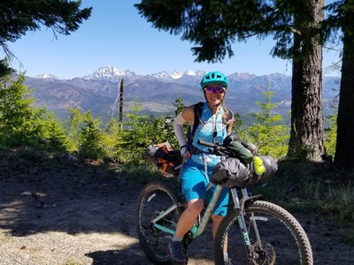
Cle Elum Ridge—Teanaway Ridge
An exhilarating and very strenuos bikepack from Roslyn to the Mineral Springs Campground. With car shuttle, it's 35 miles one-way with 4,600 feet of elevation gain. The route is on moderately difficult single-track and forest roads.
getting there
roslyn
Drive I-90 E and take Exit 80 to Bullfrog Rd. Follow Bullfrog Rd and SR-903 to Roslyn. Once in Roslyn park at the Pioneer Park parking lot at the Coal Mines Trailhead and ride to the Ewok Trailhead at the end of North 2nd Street.
Mineral Springs Campground
Drive US-97 to 18 miles north of Cle Elem or 33 miles south of Leavenworth and turn west into the Mineral Springs Campground.
on the trail
Ride the Ewok Trail or combination of forest road and single-track trail up the Cle Elum Ridge from Roslyn. Once on the top of the ridge, on clear days enjoy amazing views of Mount Rainier on one side and Mount Stuart, the Enchantment Range, and the entire Teanaway Valley on the other. After a short section on the main ridge forest road, descend an exhilarating and moderately technical single-track spur trail to the West Fork of the Teanaway River. Take a refreshing dip in the river, refill water bottles, and take a lunch break. An outhouse is available here. Bike a short section on the paved Teanaway Road to the second and most strenuous climb of the day, Dickey Creek Road to nearly the high point on Teanaway Ridge. From the high point on the road consider a side trip to the Red Top Mountain summit. The descent to the Mineral Springs Campground is fast—make sure you have breaks in good working order! After an overnight at the campground retrace the route back or a shuttle back to Roslyn.
notes
- Camp at Mineral Spring Campground where water is available.
- This trip can be combined with the Palouse-to-Cascades route or extended to include the Haney Meadow route.
- Suitable Activities: Bikepacking
- Seasons: June, July, August, September
- Weather: View weather forecast
- Difficulty: Bikepacking MTB II, Bikepacking MTB III
- Length: 35.0 mi
- Elevation Gain: 4,600 ft
- 4,900 ft
-
Land Manager:
Okanogan-Wenatchee National Forests
Cle Elum Ranger District (OWNF)
- Parking Permit Required: Northwest Forest Pass
- Recommended Party Size: 12
- Maximum Party Size: 12
- Maximum Route/Place Capacity: 12
- Green Trails Alpine Lakes East (Stuart Range) No. 208SX
This is a list of titles that represent the variations of trips you can take at this route/place. This includes side trips, extensions and peak combinations. Not seeing a title that fits your trip? Log in and send us updates, images, or resources.
- Cle Elum to Mineral Springs
- Roslyn to Mineral Springs
| Name/Description |
|---|
| Ride with GPS Map A Ride with GPS map of the bikepack route from Cle Elum to the Mineral Springs Campground posted on Jun 13, 2020. |
| Gaia GPS Map A Gaia GPS map of the bikepack route from I-90, Exit 80 near Cle Elum to the Mineral Springs Campground posted on Jun 22, 2020. |
| Cross-Washington Mountain Bike Route (XWA) The bikepack route from Roslyn to the Mineral Springs Campground is part of the Cross-Washington Mountain Bike Route (XWA) described on bikepacking.com. |
