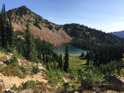
Cradle Lake
This strenuous 3,200-foot climb in the Alpine Lakes Wilderness off of Icicle Creek near Leavenworth can be done via Jack Creek, French Creek, Snowall Creek, Meadow Creek, and Blackjack Ridge. With these trails, there are many options for out-and-back and loop day hikes and backpack trips.
The clear mountain air, strenuous climbing, and glorious scenery should have you sleeping like a baby when staying at Cradle Lake. But it's not the sleep you will come here for. It's the waking hours that make this trip a pleasure, especially if you like river valleys, old growth forests, and wildlife viewing opportunities. As a bonus, you'll find high alpine meadows, great mountain views, and peaceful alpine pools by which to camp.
Getting There
Drive SR-2 to Leavenworth on turn east onto Icicle Creek Road at the west end of town. Drive ~18 miles to the Rock Creek Campground and Jack Creek Trailhead (2,960 ft), ~20 miles to the Black Pine Campground and Blackjack Ridge Trailhead (2,820 ft), or 20.4 miles to its end and the Icicle Creek Trailhead (2,800 ft).
On the Trail
Cradle Lake via Jack Creek
19.2 miles round trip, 3,500 feet of elevation gain, High Point: 6,200 ft
Hike the Jack Creek Trail 5.4 miles, turn right onto the Meadow Creek Trail, and hike 1.6 miles. Turn right onto the Snowall Creek–Cradle Lake Trail and hike 2.7 miles to Cradle Lake, passing the junction with the primitive Blackjack Ridge Trail at 1.5 miles.
Cradle Lake via Snowall Creek
Hike the Icicle Creek Trail 1.5 miles and turn left onto the French Creek Trail. Hike 4.7 miles, turn left onto the Snowall Creek–Cradle Lake Trail, and hike 5.6 miles to Cradle Lake.
Cradle Lake via Blackjack Ridge
Hike the Balckjack Ridge Trail 8.3 miles, turn right onto the Snowall–Cradle Lake Trail, and hike 1.2 miles to Cradle Lake. Hike Note that after the first 3.3 miles, the Blackjack Ridge Trail is primitive and hard to follow.
Cradle Lake Loop
Jack Creek, Snowall Creek, Blackjack Ridge, French Creek, and Meadow Creek provide many options for loop trips.
French Ridge
14 miles round trip, 3,000 feet of elevation gain, 5,800 ft high point
Hike the Icicle Creek Trail (No. 1551) from the at Icicle Creek Trailhead 1.5 miles to the junction with the French Creek Trail (No. 15925) and another 0.4 mile to the French Ridge Trail (No. 1594). Turn left and hike up the French Ridge Trail ~5 miles to the site of a form lookout at 5,800 ft.
- Suitable Activities: Backpacking, Day Hiking
- Seasons: July, August, September, October
- Weather: View weather forecast
- Difficulty: Strenuous, Moderate/Strenuous, Strenuous/Very Strenuous
- Length: 21.0 mi
- Elevation Gain: 3,200 ft
- 6,200 ft
-
Land Manager:
Okanogan-Wenatchee National Forests
Alpine Lakes Wilderness, Wenatchee River Ranger District (OWNF)
- Parking Permit Required: Northwest Forest Pass
- Recommended Party Size: 8
- Maximum Party Size: 8
- Maximum Route/Place Capacity: 8
- Green Trails Alpine Lakes East (Stuart Range) No. 208SX
This is a list of titles that represent the variations of trips you can take at this route/place. This includes side trips, extensions and peak combinations. Not seeing a title that fits your trip? Log in and send us updates, images, or resources.
- Cradle Lake via Jack Creek
- Cradle Lake via Snowall Creek
- Cradle Lake via Blackjack Ridge
- Cradle Lake Loop
- French Ridge
- French Creek
There are no resources for this route/place. Log in and send us updates, images, or resources.
