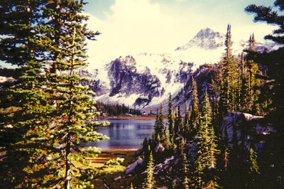
Eagle Cap Lakes Basin Loop
This moderate to strenuous loop hike in Oregon's Wallowa mountains passes granite domes, high lakes, and wildflower-filled meadows with many side-trip options. It goes to the Lakes Basin from the north and is a trip of 30 miles and 3,900 feet total elevation gain.
getting there
Take Exit 261 off of I-84 and drive south on OR-82 to Joseph. Drive through Joseph staying on the hightway, Main St in town, and continue as it becomes OR-351, Walllowa Lake Highway, to the Wallaowa River Trailhead at the road's end in Wallowa Lake State Park (4,640 ft).
on the trail
The Eagle Cap wilderness is the prize of Oregon's Wallowa mountains, and this is the Eagle Cap's premier trail. The route parallels the West Fork Wallowa River for 6 miles before entering Six Mile Meadow and the lakes basin. Hiking clockwise from here, the trail switchbacks past tiny Frazier Lake at 10.5 mi and then climbs past granite domes to Glacier Pass (the high point on the trail) at 13.75 miles, passing gorgeous Glacier Lake nestled below Eagle Cap Ridge. Steeply descending, the trail passes a string of lovely lakes in wildflower-strewn meadows before returning to Six Mile Meadow at 24 miles.
Side Trip
For a short side trip from Mirror Lake, hike the 4-mile round trip boot path that climbs to the top of 9,572-foot Eagle Cap.
- Suitable Activities: Backpacking
- Seasons: July, August, September, October
- Weather: View weather forecast
- Difficulty: Moderate/Strenuous
- Length: 30.0 mi
- Elevation Gain: 3,900 ft
- 9,572 ft
- Land Manager: Land Manager Varies
- Parking Permit Required: Northwest Forest Pass
- Recommended Party Size: 12
- Maximum Party Size: 12
- Maximum Route/Place Capacity: 12
- Green Trails Wallowa Mountains No. 475SX
There are no resources for this route/place. Log in and send us updates, images, or resources.
