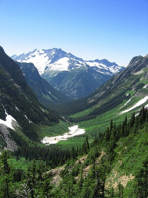
Easy Pass & Fisher Creek Basin
A strenuous backpack over Easy Pass and into Fisher Creek basin to Fisher camp. From nps.gov, "Many believe the Easy Pass and Fisher Basin area to be one of the most superb places in the North Cascades. Extensive meadows are crowned by glacial peaks. The short, steep trail to the pass is anything but 'easy.'" Enjoy views of Mount Logan, Fisher Peak, and Mount Arriva, wildflowers throughout the summer season and larches turning yellow in the fall.
getting there
Drive SR-20 to the Easy Pass trailhead between Mileposts 151 and 152. There is room for about ten cars, and bathroom facilities are available.
ON THE TRAIL
Follow the Easy Pass Trail up and over easy pass and descend into Fisher Creek Basin. Camp at Fisher Camp. The east side trail is well graded and a very easy ascent, on the west side it drops quickly into the basin on a steep and heavily switch backed trail. The ascent starts off with a stroll through a dense forest, a very nice bridge crossing and a number of very well constructed foot bridges elevating the hiker over mudded areas. At about 5,500 ft the forest ends and opens into flowering meadows with a good view of the pass. There is little shade left at this point until the bottom of the basin on the other side of the pass. Ascend the trail through a few boulder fields. At 6,500 ft, you'll be at the pass. Astounding views to the west of glacial peaks and into the basin with a few larch trees for fall colors as well.
notes
- Day hiking out-and-back to Easy Pass is 7 miles round trip.
- Camping is not allowed at the pass.
- Fisher Camp has three camp spots, two support one tent each, while the third can support four tents.
- There is easy access to water in the basin, and few small creeks during the ascent. There is next water after the pass is at Fisher Creek.
- Snow can persist late into the season.
- At the pass there are a few very accessible scrambles.
- In the winter the slope on the east side is a nice intermediate ski, and the slope on the west side is for experts.
- Suitable Activities: Backpacking, Day Hiking
- Seasons: July, August, September, October
- Weather: View weather forecast
- Difficulty: Strenuous
- Length: 11.0 mi
- Elevation Gain: 2,800 ft
- 6,674 ft
- Land Manager: North Cascades National Park
- Parking Permit Required: Northwest Forest Pass
- Recommended Party Size: 12
- Maximum Party Size: 12
- Maximum Route/Place Capacity: 12
- USGS Mt Logan
- Green Trails Washington Pass No. 50
- Trails Illustrated North Cascades National Park
There are no resources for this route/place. Log in and send us updates, images, or resources.
