Elwha to Hurricane Hill
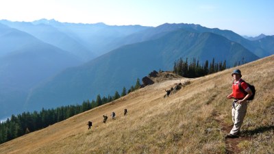
The Elwha to Hurricane Hill hike is a very strenuous, 12.4 mi round trip hike with 5,300 ft in elevation gain. The trail ascends through forest and breaks out in the meadows on Hurricane Ridge with views of the Olympics and Mount Olympus.
getting there
Heading west past Port Angeles on US 101, turn left onto Olympic Hot Springs Road. Drive past the Elwha Ranger Station and turn left onto Whiskey Bend Road. Just up the hill and on the left is the trailhead and parking.
On the trail
Start a steep climb through forest and keep climbing for 4 mi until breaking out into a vast meadow. As one climbs higher in the meadow more views are available of the mountains in the interior of the Olympics and views of the Elwha River. After 2 mi turn the trail reaches the Hurricane Hill Trail. Turn left for the short climb to the summit of Hurricane Hill at 5,757 ft. Views of the Bailey Range, Mount Olympus and the Strait of Juan de Fuca.
An alternate route is the Little River, Hurricane Hill, Elwha River Traverse. This route is 17 miles and 5,100 feet of elevation gain.
- Suitable Activities: Day Hiking
- Seasons: June, July, August, September, October
- Weather: View weather forecast
- View avalanche forecast.
- Difficulty: Very Strenuous
- Length: 12.4 mi
- Elevation Gain: 5,277 ft
- 5,757 ft
- Land Manager: Olympic National Park
- Parking Permit Required: Northwest Forest Pass
- Recommended Party Size: 12
- Maximum Party Size: 12
- Maximum Route/Place Capacity: 12
- Green Trails Hurricane Ridge/Elwha North No. 134S
- Custom Correct Hurricane Ridge
- Trails Illustrated Olympic National Park
This is a list of titles that represent the variations of trips you can take at this route/place. This includes side trips, extensions and peak combinations. Not seeing a title that fits your trip? Log in and send us updates, images, or resources.
- Little River, Hurricane Hill, Elwha River Traverse
There are no resources for this route/place. Log in and send us updates, images, or resources.
