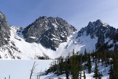
Dragontail Peak/Triple Couloirs
An intermediate-level ice climb rated Grade III, WI3. It's 12.5 miles with 7,030 feet of elevation gain and 70- to 80-degree water ice climbing. A cascade class route that climbs three couloirs up the north face of Dragontail Peak.
getting there
Drive US-2 east to Leavenworth. Just before entering town, turn right on Icicle Creek Road. Follow Road 8.5 miles to Bridge Creek Campground. Turn left and drive through campground, cross the river to Eightmile Creek Road (Forest Road 7601). Drive 4 mi to start of Lake Stuart Trailhead (3,600 ft).
APPROACH
Take Lake Stuart Trail for 2.5 mi, then go left on the Colchuck Lake Trail. Reach Colchuck Lake (5,570 ft) in another 1.8 mi. There are campsites on both the west side and the south end of the lake. Camp as near the south end as possible.
ASCENT ROUTE
The climb starts just climbers east of lowest point of Dragontail Peak's north face. Enter the hidden couloir and climb on 40- to 50-degree snow and ice for about 800 feet. At this point you will reach the steep ice runnels for about three pitches (140 meters) of 70- to 80-degree ice and mixed climbing to reach the second couloir. Then climb the second couloir for 600 feet on 40- to 50-degree snow and ice. The transition west (climber's right) into the third couloir for 200 feet of climbing which will bring you to the northeast face of the summit. From here traverse the ridge to the the true summit.
DESCENT ROUTE
Descend southeast to the saddle, then east on a long snow slope to Aasgard Pass. From Aasgard Pass descend to Colchuck Lake. Routefinding from Aasgard Pass can be tricky: stay to center left at top to avoid cliffs; below cliffs move to right side of gully.
TRIP PROFILE
| SEGMENT | TIME (HR) | ELEVATION GAIN (FT) |
|---|---|---|
| Trailhead to Camp | 2-6 | 2,000 |
| Camp to Summit | 5-9 | 3,200 |
| Summit to Camp | 2 | |
| Camp to Trailhead | 2-4 |
EQUIPMENT
Ice ax, ice tool(s) and ice screws.
NOTES
- The approach, usually a 5 mile hike to Colchuck Lake, is often more in winter when Eightmile road is gated.
- If you plan to stay overnight during May through October you will need an Enchantments Wilderness Area permit.
- Suitable Activities: Climbing
- Climbing Category: Intermediate Alpine
- Seasons: January, February, March, April, May, November, December
- Weather: View weather forecast
- View avalanche forecast.
- Difficulty: Intermediate Ice Climb
- Length: 12.5 mi
- Elevation Gain: 7,030 ft
- 8,840 ft
-
Land Manager:
Okanogan-Wenatchee National Forests
The Enchantments, Wenatchee River Ranger District (OWNF)
- Parking Permit Required: Northwest Forest Pass
- Recommended Party Size: 4
- Maximum Party Size: 8
- Maximum Route/Place Capacity: 8
- USGS Cashmere Mtn
- Green Trails Alpine Lakes East (Stuart Range) No. 208SX
- USGS Enchantment Lakes
- Green Trails The Enchantments No. 209S
There are no resources for this route/place. Log in and send us updates, images, or resources.
