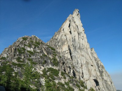
Prusik Peak/West Ridge
The West Ridge of Prusik Peak is rated Grade II, 5.7.
getting there
Drive US-2 over Stevens Pass to just west of Leavenworth. Turn right on Icicle Creek road and drive 8.6 mi to Eightmile Road. Turn left and drive 3.5 mi to end and the Stuart Lake Trail, 3,600 ft.
APPROACH
Hike trail about 2.5 mi to Colchuck Lake Trail 1559A. Follow the trail across Mountaineer Creek, then south through boulders and up switchbacks 1.6 mi to Colchuck Lake, 5,570 ft.
To ascend Aasgard Pass (labeled Colchuck Pass on USGS Enchantment Lakes map), follow the path around the lake to the large boulders at the south end of the lake. Follow the stream staying to the left and eventually going left of the first cliffs. Continue southeast up rock and heather, or snow in early season, to just northeast of Aasgard Pass and upper limit of the Enchantment basin.
Descend easterly through the lake system of the upper plateau. When the route drops from Talisman Lake to Rune Lake (Inspiration and Perfection, respectively, on USGS Enchantment Lakes map) ascend to Prusik Pass and up the West Ridge until it steepens.
ASCENT ROUTE
Two pitches of class 4 and low class 5 lead to the crest of the West Ridge. The third pitch begins with a short unprotected 5.7 friction slab followed by easier climbing. Traverse on the south side of a prominent horn to a belay on the ridge. Traverse left, class 4, via ledges on the north side until under the summit. From the highest easy ledge lie back up a steep corner, 5.6, for about 10 ft or jam and mantle onto ledge that leads out and right. Climb a right facing thin flake to another ledge. A short narrow chimney leads to the summit.
DESCENT ROUTE
Descend off the north face with three to four single rope rappels or various combinations of double and single rope rappels. When able traverse left, west, to Prusik Pass at the base of the West Ridge.
TRIP PROFILE
EQUIPMENT
Rack to 3-1/2 in, ice ax, crampons in early season.
NOTES
Clean, solid granite on a classic ridge. Permits are required and can be difficult to obtain except well in advance. Numerous camp sites available in Enchantments.
- Suitable Activities: Climbing
- Climbing Category: Intermediate Alpine
- Seasons: May, June, July, August, September
- Weather: View weather forecast
- Difficulty: Intermediate Rock Climb
- Elevation Gain: 4,400 ft
- 8,000 ft
-
Land Manager:
Okanogan-Wenatchee National Forests
The Enchantments, Wenatchee River Ranger District (OWNF)
- Parking Permit Required: Northwest Forest Pass
- Recommended Party Size: 6
- Maximum Party Size: 8
- Maximum Route/Place Capacity: 8
- Green Trails Mt Stuart No. 209
- USGS Enchantment Lakes
- USGS Cashmere
- Green Trails Alpine Lakes East (Stuart Range) No. 208SX
There are no resources for this route/place. Log in and send us updates, images, or resources.
