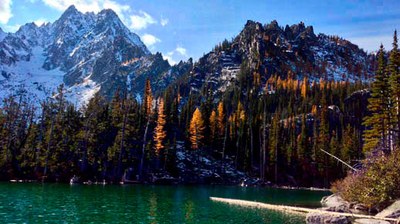
Entiat River Meadows & High Country
The trail system around the headwaters of the Entiat River and neighboring Entiat Mountains offer options for miles of wandering and wild, uncrowded camping among meadows, lakes and snowy peaks, framed in the fall by golden larch. Options for exploration include Entiat Meadows, Ice Lakes, Larch Lakes and Fifth of July Mountain.
driving directions
You often won't encounter a soul on these trails, and there is a reason: the trailhead for wandering the Entiat meadows and high country is a good 3.5 hours from Seattle, including a very long drive up the Entiat River Road from highway 97 on the east side of the Cascades.
on the trail
The vast flowerfield expanse of Entiat Meadows under the glaciers of Seven Fingered Jack, Mount Fernow and Mount Maude are reached via the 14.7 mile (each way) Entiat River Trail (No. 1400). Great camps can be found near the junction of the Snow Brushy Creek Trail (No. 1230) around mile 6. It is possible to loop back from the meadows on a high trail, the Cool Creek Trail (No. 1431), re-joining the main Entiat River trail at mile 7.9.
Take a fabulous loop trip into the Entiat Mountains by taking a left at mile 3.6 on the Cow Creek Meadows Trail (No. 1404), going up 0.6 miles and turning right on the Larch Lakes Trail (No. 1430.1) just past Myrtle Lake and climbing another 2.6 miles to camps in the meadows between lower and upper Larch Lakes. A side trip to walk up nearby Fifth of July Mountain (an additional 6 miles round trip from upper Larch Lake) is a must-do with fantastic views to the heart of the Cascades and the Glacier Peak Wilderness. The loop can be completed by heading back down the Cow Creek Meadows Trail (No. 1404) for 3.6 miles from Fifth of July Mountain, past Myrtle Lake and back to the main Entiat River Trail. There is another, seemingly more direct way up to Larch Lakes, turning left from the Entiat River trail at mile 4.7, however, this route requires wading the Entiat River which can get hairy at times.
If more time is available, follow the Pomas Creek Trail (No. 1453), up and over Pomas Pass and back down to the junction of the Ice Creek Trail, 5.3 miles from Upper Larch Lake. (From Pomas Pass it is possible to cross into the Chiwawa River drainage and connect with the trail to Carne Mountain and Phelps Creek Trails.) Turning left on the Ice Creek Trail (No. 1405), go 4 miles to lower Ice Lake in its stark bowl of scree and pumice. Camp on the pumice flats, not on the fragile meadows. A side trail picks its way through the rocks another 1.5-2 miles to Upper Ice Lake, under the looming face of 9,082-foot Mt Maude. Return back the way you came for 5.9 miles, going straight at the Pumas Creek Trail junction to join the Entiat River Trail. Turn right to return 7.9 miles to the trailhead, or turn left to reach Entiat Meadows in 6.8 miles.
- Suitable Activities: Backpacking
- Seasons: July, August, September, October
- Weather: View weather forecast
- Difficulty: Very Strenuous, Strenuous
- Length: 56.0 mi
- Elevation Gain: 8,900 ft
- 7,200 ft
-
Land Manager:
Okanogan-Wenatchee National Forests
Glacier Peak Wilderness, Entiat Ranger District (OWNF)
- Parking Permit Required: Northwest Forest Pass
- Recommended Party Size: 8
- Maximum Party Size: 12
- Maximum Route/Place Capacity: 12
- Green Trails Lucerne No. 114
- Green Trails Holden No. 113
There are no resources for this route/place. Log in and send us updates, images, or resources.
