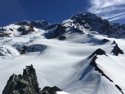
Glacier Island Traverse
A grand ~3 mile glacier travel traverse on the western slopes of Mount Rainier with sweeping views of Success Cleaver and the Sunset Amphitheater.
Getting There
Take I-5 to exit 142. Exit to SR 161 and drive south until exiting at SR 512 West. Travel 2-3 mi and get off at Puyallup exit (Mount Rainier sign). Drive via Eatonville and SR 706 to the Nisqually entrance to Mount Rainier National Park (approximately 80 mi from Seattle). Pay entrance fee and drive 1 mi to the West Side Road, turn left and take it as far as it is open, (barricade at Dry Falls, 2,840 ft, in 2015) toward Tahoma Creek Trailhead, 3,500 ft, 4.7 mi. from the start of the West Side Rd.
APPROACH
Hike up road approximately a half hour, to Tahoma Creek Trail. Ascend the Tahoma Creek Trail to the junction with the Wonderland Trail at ~4300 ft. elevation. Turn south, cross the Tahoma Creek suspension bridge and hike to the Mirror Lakes area by way of Indian Henry's Hunting Ground. There is a convenient outhouse behind the Indian Henry's Ranger Station.
From Mirror Lakes proceed cross country in an easterly direction to reach the basin that is SW of Pyramid Peak. After stopping to fill water containers, proceed in a north easterly direction to reach the gentle 6631 ft. summit that is north of Pyramid Peak. Proceed up Success Cleaver (after a brief ~200 ft. descent) to the start of glacier travel at ~8000 ft. Potential campsites include the flat area just north of the 6631 ft summit, or for those interested in an easier second day, the flat area near a large boulder at ~8100 ft on the Success Cleaver.
TRAVERSE ROUTE
Rope up for glacier travel and traverse the South Tahoma Glacier at a nominal elevation of ~8100 ft to reach the Tahoma Cleaver at ~8100 ft. Take advantage of the vantage point on Success Cleaver to plan the best line for this traverse. From the Tahoma Cleaver ascend a short distance SW to an unnamed summit with dramatic views of the Sunset Amphitheater. Cross onto the Tahoma Glacier and circle under (and to the west) of the summit just visited at the ~7400 ft elevation to reach the col between this summit and the summit of Glacier Island Peak. Descend to the NW, then move north to cross the pressure ridge to reach the main part of the Tahoma Glacier.
Finally, proceed in a SW direction to negotiate the jumbled/bouldery conditions on the glacier that ultimately leads to the alpine ridge containing Point 6032. Descend this ridge to reach the Wonderland Trail being cognizant of the cliffs immediately below. Descend south on the Wonderland Trail to rejoin the original approach at the Tahoma Creek suspension bridge. An alternate but longer exit route that offers a visit to the columnar basalt near the South Puyallup camp site is to travel north on the Wonderland Trail, then west on the connector trail to reach Round Pass on the West Side Road.
EQUIPMENT
Standard glacier gear, pickets and screws.
NOTES
- The Tahoma Creek Trail is closed due to flash flooding, but is passable. The flooding is due to sudden releases from the glacier. Familiarize yourself with warning sounds from the flooding and be prepared to seek refuge on high ground.
- The South Tahoma Glacier and Tahoma Glaciers are heavily crevassed and careful route finding is required with the route deviating from year to year.
- The ridge crest of Glacier Island Peak has several hazards that make an ascent as a basic experience climb problematic and undesirable. In early season there are large cornices, and after these cornices melt (or even during this melting) large bergschrunds form (some immediately below the ascent route required to deal with vertical snow left over from cornice calving).
- Owing to glacier travel, a climbing permit is required; obtain either at Longmire or Paradise.
- Check with Mount Rainier National Park (land manger link below) to be sure you have the required camping and climbing permits.
- Suitable Activities: Climbing
- Climbing Category: Basic Alpine
- Seasons: May, June
- Weather: View weather forecast
- Difficulty: Basic Alpine Climb
- Length: 15.0 mi
- Elevation Gain: 5,600 ft
- 8,100 ft
- Land Manager: Mount Rainier National Park
- Parking Permit Required: National Park Entrance Fee
- Recommended Party Size: 6
- Maximum Party Size: 12
- Maximum Route/Place Capacity: 12
- USGS Mt Rainier West
- USGS Mount Wow
- Green Trails Mount Rainier Wonderland No. 269SX
