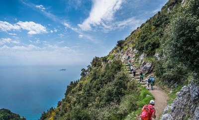
Hike the Amalfi Coast and Cilento National Park in Southern Italy
Day-hike along the medieval mule tracks of the Alta Via dei Monti Lattari and the coastal paths of the Cilento National Park on Italy's Amalfi Coast to experience the natural beauty and the picturesque landscapes of this Unesco World Heritage Site. Moderate physical challenge is rewarded by stunning views of the Mediterranean, alpine mountains and meadows, charming towns built into the rocky terrain and taking in the rich cultural and archeological history of the area. Carry only daypacks, enjoy great food and relax in comfortable lodging at night.
Italy's Amalfi Coast, listed as a UNESCO World Heritage site in 1997, is one of the most beautiful coastlines in Italy. Picturesque coastal towns, mountains and valleys showcase the natural and cultural richness of the area. Going from the mountains to the sea, this mosaic-terraced landscape includes vineyards, rural chapels, watermills, farmhouses, castle ruins, forests, rocks and meadows with flowers and wild herbs.
Avid hikers can experience:
- the many medieval mule tracks now converted to hiking trails, called the Alta Via dei Monti Lattari, a 55-mile hiking trail that runs from Cava dei Tirreni on the Amalfi Coast, arguably Italy’s most picturesque coastline, all the way to the tip of the Sorrento Peninsula and inland to the highest mountains in the area. The Amalfi coast section winds and snakes through old vineyards, past rugged cliffs and ancient farming land, providing a stunning combination of quaint coastal towns, mountains, rich culture and fascinating wildlife. As you continue along the trail beyond the Amalfi Coast, you’ll be met by olive groves, small churches, ancient castle ruins, and old farm houses.
- Cilento National Park, a paradise of jagged coastline and inland hills that combine beautiful seas with green natural splendor, quaint fishing villages and time-worn hill towns resting amidst forested foothills south of the famous Amalfi Coast but without the Amalfi's crowds and tourist shops, plus street markets where locals shop and small stores for everyday life, and ancient monuments like the incredibly well preserved Greek temples of Paestum and the Greco-Roman remains of Velia.
- the island of Capri, a quintessential sundrenched island in the Tyrrhenian Sea off the Sorrento Peninsula. Capri has been a resort since the time of the Roman Republic. Some of the main features of the island include the Marina Piccola (the little harbor), the Belvedere of Tragara (a high panoramic promenade lined with villas), the limestone crags called sea stacks that project above the sea (the faraglioni), the town of Anacapri, the Blue Grotto (Grotta Azzurra), the ruins of the Imperial Roman villas, and the vistas of various towns surrounding the Island of Capri including Positano, Amalfi, Ravello, Sorrento, Nerano, and Naples.
Day hikes are rugged and of moderate difficulty, with some areas of exposure, but well within the reach of the average fit hiker. And it's possible to hike during the day and retreat to comfortable lodging in the evening (many of which are local Agri turismo’s that serve home grown local specialties). This means you can explore with just a daypack if that appeals!
Getting to the Amalfi Coast
There is no Amalfi Coast airport; the nearest airport to the Amalfi Coast is the Naples Capodichino Airport, located about 37 miles to the north. However, depending upon where you are departing from, you may find that the best airport for the Amalfi Coast is Rome Fiumicino (185 miles north), which connects with more cities. If you’re flying into Rome, consider that it will take you about four hours to reach the Amalfi Coast by public transportation (train + bus). Trains connect to Sorrento, and from there one can take a ferry to Capri or a bus between all the coast towns. However, many choose to drive, and a 34 mile highway (SS163 highway or Amalfi Drive) runs the length of the Amalfi Coast, connecting all of the towns along the coast and considered to be one of the most scenic drives in the world.
- Suitable Activities: Day Hiking, Global Adventures
- Seasons: March, April, May, September, October, November
- Weather: View weather forecast
- Difficulty: Moderate, Strenuous
- Land Manager: Land Manager Varies
- Parking Permit Required: see Land Manager
- Recommended Party Size: 12
- Maximum Party Size: 12
- Maximum Route/Place Capacity: 12
There are no resources for this route/place. Log in and send us updates, images, or resources.
