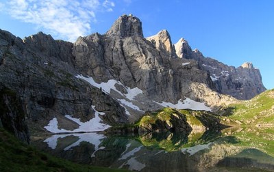
Trek Hut to Hut on the Alta Via 1 in Italy's Dolomites
The Dolomite Mountains in the northeast corner of Italy offer a paradise for walkers and adventurers of all levels. And cutting through this wonderland from north to south is the Alta Via 1. Villages, resorts and remote mountain huts are connected with convenient public transport and opportunities for amazing food.
Italy's Dolomites or "Pale Mounts" are unique among mountains in the Alps for their soaring pinnacles of calcium carbonate rich rock (or "dolomite") . These peaks are comprised of several self-contained formations that rise high in rock spires and sculpted pinnacles that shine bright in the sun and glow orange-pink at sunset. It's no wonder that this trip is one of the most popular routes in the Italian mountains and in all of Europe.
Italy's Alta Via 1 passes through several of these unique formations including the Fanes, Lagazuoi, Cortina, Pelmo, Civetta, Moiazza and Dolomiti Bellunesi, providing great variety. It covers a distance beginning at Lago di Braes at the north to La Pissa in the south, over approx 75 miles, and is typically completed in 9 to 11 days. The highest point is 2752m or approx 9020 feet. This is a challenging route if done in one trip, with a total elevation gain ranging from 1800 to 4300 feet a day and distances from 4 to 12 daily miles depending on how quickly you travel. Many mountain hut options and some village hotels are available along the route providing considerable flexibility. The mountain huts offer meals and beds in private or dormitory style, and one can also camp and dayhike in many locations along the way.
The Alta Via 1 can be accessed readily by air from Venice or Treviso. Public transport to and from the Alta Via 1 is well organized and there are plenty of options to start and end the trail at intermediate points along the route.
- Suitable Activities: Backpacking, Day Hiking, Global Adventures
- Seasons: Year-round, July, August, September
- Weather: View weather forecast
- Length: 75.0 mi
- Elevation Gain: 9,020 ft
- Land Manager: Land Manager Varies
- Parking Permit Required: see Land Manager
- Recommended Party Size: 10
- Maximum Party Size: 12
- Maximum Route/Place Capacity: 12
There are no resources for this route/place. Log in and send us updates, images, or resources.
