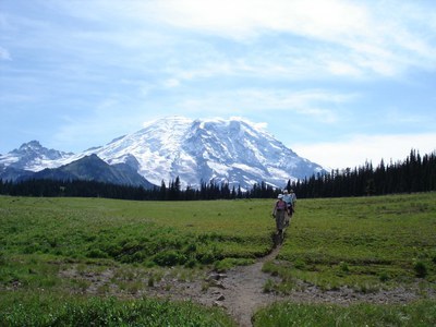
Grand Park, Scarface & Mount Fremont
From just outside Mount Rainier National Park's northern boundary, hike to Lake Eleanor and then on to Grand Park. Traverse Grand Park and scramble Scarface and/or Mount Fremont with a loop through Cold Basin. Both are good scrambles in the northeast corner of Mount Rainier National Park after the road to Sunrise closes.
Getting There
From Enumclaw and drive east on SR-410 toward Mount Rainier. Turn right on Forest Road 73 and drive 10 miles to Eleanor Creek. At this point the road is almost directly on the northern border of the Mount Rainier National Park, and there is a sign on the left side of the road marked "Eleanor Creek (elev 4520)." Park just past the sign (5,120 ft).
on the trail
Lake Eleanor (5,000 ft)
2 miles round trip with 400 feet of elevation gain, 5,000 ft high point
Hike form just outside Mount Rainier National Park one mile to Lake Eleanor.
grand park (5,600 ft)
9 miles round trip with 1,100 feet of elevation gain
Hike past Lake Eleanor in old growth forest to a two mile long wildflower meadow with views of Mount Rainier.
Huckleberry Creek–Sunrise Area–Lake Eleanor Loop
18-mile loop with a short 4.1-mile car shuttle, 4,700 feet of elevation gain
See our Huckleberry Creek route/place for more info and to schedule a trip.
Approach & Ascent
Scarface—Grand Park Traverse (6,108 ft)
8 miles round trip, 2,500 feet of elevation gain, difficulty: Strenuous 3, Technical 2
Look for boot path just east of the Eleanor Creek and head south. Reach the park boundary in about a hundred yards. The trail is obvious and easy with a few downed logs and leads to Lake Eleanor. From the lake head east along the maintained Lake Eleanor Trail until reaching a ridge at 5,020 ft. Leave the trail and head west to Scarface (6,108 ft). Ascending on the ridge is the preferred route though at times it may be bets to travel just left of the ridge. From Scarface take ridge heading south and continue southerly until reaching Grand Park. Note that there are many game trails on this ridge. From Grand Park, return to Eleanor Lake via the maintained Lake Eleanor Trail.
Mount Fremont (7,181 ft)
12 miles round trip, 3,500 feet of elevation gain, difficulty: Strenuous 4, Technical 2
Hike to Lake Eleanor on a boot path and then follow the Lake Eleanor Trail into Grand Park. Descend into Cold Basin, and then ascend the north ridge of Mount Fremont. Descend the northwest ridge of Mount Fremont and hike the Lake Eleanor Trail through Grand Park back to the lake and then the boot path to the cars. This trip can also be done as an out-and-back through Grand Park.
- Suitable Activities: Backpacking, Day Hiking, Scrambling
- Seasons: July, August, September
- Weather: View weather forecast
- Difficulty: Strenuous 3, Technical 2
- Length: 8.0 mi
- Elevation Gain: 2,500 ft
- 6,108 ft
-
Land Manager:
Mount Rainier National Park
Mount Rainier Wilderness
- Parking Permit Required: National Park Entrance Fee
- Recommended Party Size: 12
- Maximum Party Size: 12
- Maximum Route/Place Capacity: 12
- Green Trails Mount Rainier Wonderland No. 269SX
- USGS Sunrise
- Green Trails Mt Rainier East No. 270
This is a list of titles that represent the variations of trips you can take at this route/place. This includes side trips, extensions and peak combinations. Not seeing a title that fits your trip? Log in and send us updates, images, or resources.
- Lake Eleanor
- Lake Eleanor (Mount Rainier)
- Grand Park
- Grand Park (Mount Rainier)
- Scarface
- Scarface—Grand Park Traverse
- Mount Fremont
- Mount Fremont—Grand Park Traverse
- Cold Basin, Mount Fremont & Grand Park Loop
There are no resources for this route/place. Log in and send us updates, images, or resources.
