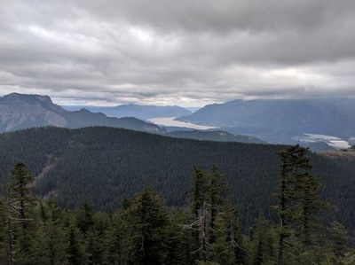
Hardy Ridge
A moderate 8.1 mile hike with 2,226 feet of elevation gain. The ridge has a view of Table Mountain, Bonneville, and parts of the Columbia River Gorge.
Getting there
Drive SR-14 to Beacon Rock State Park, 34 miles east of Vancouver, WA. Turn left at Kueffler Rd (next to a large Beacon Rock State Park sign), drive 1 mile to an intersection and "Equestrian Trailhead" sign.. Turn right and drive 0.4 miles to the picnic area and trailhead (840 ft).
on the trail
hardy ridge loop
8.1 miles round trip with 2,226 feet of elevation gain
Hike out the West Hardy Ridge Trail and loop back on the East Hardy Ridge Trail.
INFORMATION FOR LEADERS
Scheduling
Please review our Beacon Rock route/place if you plan a side trip there and be sure to coordinate with other groups to minimize our impact.
permits
The Mountaineers has a commercial use permit with Washington State Parks for all free and fee-based outings at state parks. Leaders should carry a print or digital copy of our commercial use permit to show rangers they may encounter.
- Suitable Activities: Day Hiking
- Seasons: Year-round
- Weather: View weather forecast
- Difficulty: Moderate
- Length: 8.1 mi
- Elevation Gain: 2,226 ft
- 2,868 ft
- Land Manager: Beacon Rock State Park
- Parking Permit Required: Discover Pass
- Recommended Party Size: 12
- Maximum Party Size: 12
- Maximum Route/Place Capacity: 12
- Green Trails Columbia River Gorge West No. 428S
- see Land Manager
This is a list of titles that represent the variations of trips you can take at this route/place. This includes side trips, extensions and peak combinations. Not seeing a title that fits your trip? Log in and send us updates, images, or resources.
- Hardy Ridge Loop
- Hardy Ridge & Creek
- Hardy Ridge & Creek Loop
- Hardy Ridge & Beyond
- Hardy Ridge & Beacon Rock
- Beacon Rock State Park
There are no resources for this route/place. Log in and send us updates, images, or resources.
