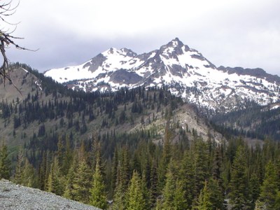
Hawkins Mountain
Hawkins Mountain is a prominent peak accessible from both the Salmon La Sac and Teanaway drainages with great views to the east and west
Driving Directions
About 5 mi past Salmon La Sac, then right on Camp Creek road (probably not marked). Up about .4 mi then on the right, just before the road ends at some maintained cabins. There is a nice trailhead camping on the site of an old burned down cabin.
Ascent Route
Follow the Big Boulder Creek trail south (USGS shows the first part as an old road ). At about 3,600 ft the trail turns southeast. Go about that same distance until the trail crosses the major southwest flowing creek. Cross the creek and leave the trail. Ascend ridge to Point 5202 and continue up to the summit.
From the top, either descend the same route, or follow the west ridge to the saddle at 6,000 ft and drop t down the west side to the old 4X4 road. Follow its switchbacks down the valley.
- Suitable Activities: Scrambling
- Seasons: June, July, August
- Weather: View weather forecast
- Difficulty: Technical 3, Strenuous 3
- Length: 7.0 mi
- Elevation Gain: 3,700 ft
- 7,160 ft
-
Land Manager:
Okanogan-Wenatchee National Forests
Cle Elum Ranger District (OWNF)
- Parking Permit Required: Northwest Forest Pass
- Recommended Party Size: 12
- Maximum Party Size: 12
- Maximum Route/Place Capacity: 12
- Green Trails Mt Stuart No. 209
- USGS Davis Peak
There are no resources for this route/place. Log in and send us updates, images, or resources.
