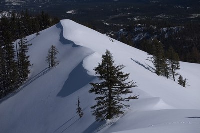
Hex Mountain (winter)
Hex Mountain is a somewhat difficult, 7 mile round trip snowshoe hike or backcountry ski tour with 2,600 feet in elevation gain. The trail is through forests and often steep, ending in panoramic views of Cle Elum Lake.
The access to Hex Mountain has been blocked due to private land now gated - see WTA place description, https://www.wta.org/go-hiking/hikes/hex-mountain-1
getting there
Take Exit 80 off of I-90 and drive north on Bullfrog Road. Turn right onto SR 903 (Salmon La Sac Road) at the round-about and drive through Roslyn. Continue 9 miles to the junction with Forest Road 116 a park at the plowed turnout (2,400 ft).
approach & ascent
Ascends to the summit via logging roads and then Trail 1343, following a ridge to the top.
ski routes
Ski runs can be done on either side of the ridge. Descend by following the trail back down or ski the basin south of the summit and connect up with the logging roads.
- Suitable Activities: Backcountry Skiing, Snowshoeing
- Snowshoeing Category: Basic
- Seasons: January, February, March, December
- Weather: View weather forecast
- View avalanche forecast.
- Difficulty: M1 Intremediate Ski, Strenuous
- Length: 7.0 mi
- Elevation Gain: 2,600 ft
- 5,034 ft
-
Land Manager:
Okanogan-Wenatchee National Forests
Cle Elum Ranger District (OWNF)
- Parking Permit Required: Northwest Forest Pass
- Recommended Party Size: 12
- Maximum Party Size: 12
- Maximum Route/Place Capacity: 12
- USGS Cle Elum Lake
- Green Trails Kachess Lake No. 208
This is a list of titles that represent the variations of trips you can take at this route/place. This includes side trips, extensions and peak combinations. Not seeing a title that fits your trip? Log in and send us updates, images, or resources.
- Hex Mountain
| Name/Description |
|---|
| Hex Map + Parking Parking area for Hex Mtn is the red spot just below the Newport Creek drainage. As you drive from Ronald or Roslyn, the last building you will see on your right is the "Last Resort" restaurant and gas station. The Hex parking area is about a mile up the road from that building, on the left hand side of the road. It is just after the fire station that's on the right hand side. |
