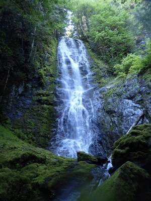
Hopkins Creek
Hopkins Creek is an Intermediate Canyon, usually rated v4a3III, located along the Cowlitz River on the south side of Mount Rainier. An open creek with rapid fire long rappels, the low to moderate flow makes Hopkins a good early season canyon.
GETTING THERE
From the west, drive to Randle on US-12. Continue east for 5.5 miles and turn onto Silverbrook Rd. In about 500 feet, there is a small pullout on the right, just after a driveway. The path from this pullout is the exit trail—walk 10 minutes up the trail to view the final waterfall. This parking area has room for two cars. If your party has more than two cars, consider parking at a pullout on highway 12 ~¼ mile further down the road on the left.
APPROACH
From the parking at the exit trail, walk down the road, back to US-12, and head east. Walk past a cutoff road with several houses. Just past this road is a dirt pullout (the alternative parking area). There's an obvious steep sandy trail leading up the embankment from the pullout. Take this trail, which becomes a clear path that switchbacks up the mountain. The trail can be very overgrown in the summer, but as you gain elevation, it becomes easier. At the end of a switchback, at ~1,700 ft, head off trail, in a northwesterly direction towards the creek. The terrain is a bit challenging but the bushwhacking isn't too bad. At ~1,800 ft, there is a spot where a tributary joins Hopkins Creek from the east. This is the drop-in.
DESCENT
Hopkins Creek has 8 rappels, the longest of which is about 240 feet, broken into two pitches. The creek is open, making it less committing, although bailing would make for a slow and unpleasant bushwhack. All rappels use natural anchors. Despite the openness, it is highly vegetated and does not get a lot of sun, so be prepared to stay warm. This is a beautiful, lush, green creek with rapid fire rappels and very little creek walking or down climbing. Most rappels are in the flow, but the flow is dispersed.
After dropping in and putting on wetsuits, scramble and down climb about 100 feet to the first rappel.
- Rappel 1: 70 ft (25 m) from a tree DCR (Down Canyon Right) into shallow pool.
- Rappel 2: 20 ft (7 m) from downed tree
- Rappel 3: 20 ft (7 m)
- Rappel 4: 100 feet (30 m) DCL (Down Canyon Left)
- Rappel 5: Upper Hopkins Creek Falls. 240 feet (80 m) from tree DCL. From the top, the tree that serves as a rebelay (also DCL) is not visible, but on rappel it is fairly easy to spot. The challenge with the rebelay is that it is quite a bit off course, and the rappeller can easily descend too low. The first person down should rig an ascent strand for the rest of the team to access the anchor. It's possible that the entire waterfall can be descended in a single, 240-foot pitch, with two 300-foot ropes.
- Pitch 1: 150 ft (50 m). This pitch stays canyon left (rappeller's right) of the main flow, and can be a bit slippery. A single, halved 300-foot rope will make it to the rebelay with about 5 feet on either end. Two 200-foot ropes are best. The first person down should be careful not to descend too far to avoid having to climb up to the rebelay.
- Pitch 2: 90 ft (28 m) largely out of the flow
- Rappel 6: 60 ft (20 m)
- Rappel 7: 80 ft (25 m) DCL
- Rappel 8: Lower Hopkins Creek Falls. 180 feet (55m) down a low angle slab. The rappeller can choose to go into concentrated flow in a crack system, or stay on the slippery slabs.
EXIT
The exit trail starts immediately after the final waterfall, and is a 10 minute walk back to the parking area on an easy-to-follow trail.
EQUIPMENT
Standard canyoning gear including replacement webbing and quick links. With many long rappels, two 200-foot ropes and a 300-foot rope (or at least three 200-foot ropes) will be useful.
TRIP PROFILE
- Rappels: 8-9
- Longest Rappel: 240 feet
- Approach: ~1 mile
- Exit: ~0.5 mile
- Time: 6-8 hours total
NOTES
- This canyon is rated v4a3III in early to mid-season, and v4a2III in late summer.
- Visit the Hopkins Creek listing on ropewiki for additional beta and updated trip reports from the broader community.
- This canyon is lush and pristine. Please take care and watch your footing to avoid damaging mossy corridors and eroding slopes.
- Suitable Activities: Canyoning
- Seasons: June, July, August, September
- Weather: View weather forecast
- Difficulty: Intermediate Canyon
- Length: 3.0 mi
- Elevation Gain: 900 ft
- 1,800 ft
-
Land Manager:
Gifford Pinchot National Forest
Cowlitz Valley Ranger District (GPNF)
- Parking Permit Required: None
- Recommended Party Size: 6
- Maximum Party Size: 12
- Maximum Route/Place Capacity: 12
- Green Trails Randle No. 301
- USGS Purcell Mtn
There are no resources for this route/place. Log in and send us updates, images, or resources.
