Hurricane Hill
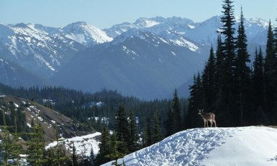
Hurricane Hill is a moderately easy, 6 mile snowshoe hike with 1,650 feet of elevation gain. On the hike you'll go through scenic alpine meadows and forests and end up on the hill with some of the best views of Mount Olympus.
Getting there
Drive US 101 to Port Angeles and then 17 miles up Hurricane Ridge Road (aka Heart o' the Hills Parkway) to the Hurricane Ridge Visitor Center.
snowshoe route
Hurricane Hill is a 6 mile round trip snowshoe that aptly deserves its name. The peak wind conditions can turn this normally stunning alpine moderately easy trip into a gale fighting slog on an exposed ridgeline. Although the total elevation change between the start and destination is 540 feet, the net ascent/descent is 1,650 feet, making the destination a game changer in new or deep snow.
The snowshoe route differs from the summer route by exiting the trail 1.6 miles in, and ascending the ridgeline. The route stays on the ridgeline until it connects to the base of the windswept meadow leading up to Hurricane Hill. The route then heads straight uphill to the summit.
Notes
- The road to Hurricane Ridge can be closed in the mornings for snow removal in winter. Check current snow and road conditions before leaving town. The Twitter Feed “Hurricane Ridge NPS” provides road opening status. Keep your cell phone on to receive Olympic National Park provided Emergency Weather Alerts via the Amber Alert feature of smart phones.
- All vehicles are required to carry tire chains when traveling above the Heart O' the Hills entrance station during the winter season. This requirement applies to all vehicles (including four-wheel-drive), regardless of tire type or weather conditions.
- Conditions can go to blinding white out in minutes via fast moving cloud cover or driving wind.
Information for Leaders
scheduling & permits
- This route allows multiple bookings. Please check scheduled trips listed below in the "Activities" tab to see if there is another group already booked on the same day. Leaders are expected to contact the leader(s) of existing trips to ensure there are no concerns or conflicts, according to The Mountaineers Outdoor Ethics Policy. Please review our Group Size & Multiple Bookings page for guidance.
- Suitable Activities: Snowshoeing
- Snowshoeing Category: Intermediate
- Seasons: January, February, March, December
- Weather: View weather forecast
- View avalanche forecast.
- Difficulty: Moderate
- Length: 6.0 mi
- Elevation Gain: 1,650 ft
- 5,757 ft
- Land Manager: Olympic National Park
- Parking Permit Required: National Park Entrance Fee
- Recommended Party Size: 12
- Maximum Party Size: 12
- Maximum Route/Place Capacity: 12
- Green Trails Hurricane Ridge/Elwha North No. 134S
- Custom Correct Hurricane Ridge
- USGS Mt Angeles
- USGS Hurricane Hill
This is a list of titles that represent the variations of trips you can take at this route/place. This includes side trips, extensions and peak combinations. Not seeing a title that fits your trip? Log in and send us updates, images, or resources.
- Hurricane Hill
There are no resources for this route/place. Log in and send us updates, images, or resources.
