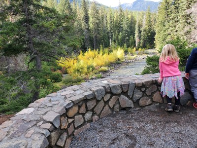
Icicle Gorge
A flat loop hike with beautiful views. Perfect for the younger kids! It only gains 150ft over 4.2 miles (roundtrip).
Getting THere
Drive US-2 to Leavenworth. When headed east into town and just before town, turn right onto the Icicle road. Drive ~22.5 miles on Icicle road (it turns to gravel after ~15.5 miles) to the Icicle Gorge trailhead (2,600 ft) on the left.
On the Trail
Icicle Gorge Loop
4-mile loop, 150 feet of elevation gain, 2,800 ft high point
This is a nature loop, so enjoy the gentle grade in and out of the forest, and take some time to read the signs as you get to them to learn about the area. Enjoy views of Icicle River, bridges, peaks, and many native plants. The trail is beautiful whether you hike it clockwise or counterclockwise.
Icicle Gorge View Loop
2.25-mile loop, 200 feet of elevation gain, 2,900 ft high point
From the Icicle Gorge Trail, branch off onto the less-traveled Icicle View Trail and enjoy views of the gorge. Loop back on the Icicle Gorge Trail.
- Suitable Activities: Day Hiking
- Seasons: April, May, June, July, August, September, October
- Weather: View weather forecast
- Difficulty: Easy
- Length: 4.2 mi
- Elevation Gain: 150 ft
- 2,800 ft
-
Land Manager:
Okanogan-Wenatchee National Forests
Wenatchee River Ranger District (OWNF)
- Parking Permit Required: Northwest Forest Pass
- Recommended Party Size: 12
- Maximum Party Size: 12
- Maximum Route/Place Capacity: 12
- Green Trails Alpine Lakes East (Stuart Range) No. 208SX
This is a list of titles that represent the variations of trips you can take at this route/place. This includes side trips, extensions and peak combinations. Not seeing a title that fits your trip? Log in and send us updates, images, or resources.
- Icicle Gorge
- Icicle Gorge Loop
- Icicle Gorge View Loop
- Icicle Gorge Creek & View Loop
There are no resources for this route/place. Log in and send us updates, images, or resources.
