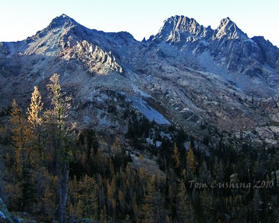
Ingalls Peak/South Peak
Ingalls Peak - South Peak is a scramble of 11 miles with 3,600 feet of gain. An intermediate scramble with a few exposed moves.
Getting there
Drive I-90 to ~1 mile east of Cle Elum, then drive northeast on SR-970 past the Teanaway River Bridge and turn left on Teanaway River Road. Continue 23 miles to the road end parking area at 4,243 ft, ~1 mile beyond the DeRoux Campground (3,900 ft). Car camping is available at the DeRoux Campground and other campgrounds on the Teanaway River Road.
Approach & Ascent
Ingalls Peak/South Peak
11 miles round trip, 3,600 feet of elevation gain, difficulty: strenuous 4, technical 3
Hike the Ingalls Lake Trail 3 miles over Ingalls Pass then another mile down to the lake. Ascend slabs, talus, and boulders to the notch between Ingalls North and South Peaks—a small spire sits in the saddle. Aim for the left of the small spire. There may be steep snow just below the saddle. Descend onto west side of ridge about 50 feet and ascend one of several gullies that lead to the ridge, ~100 feet of Class 2-3 rock. Follow ridge to summit on snow and rock.
Alternate Route: From saddle cross steep slabs and attain the broad east shoulder for an easy walk to summit.
Fortune & Ingalls Peaks
12-mile loop, 4,000 feet of elevation gain, difficulty: Strenuous 3, Technical 4
Scramble Ingalls South Peak, begin descending the west side gullies, and traverse south to the saddle between South Ingalls and Fortune Peaks. Follow just below the ridge on the basin side until an easy ascent of Fortune Peak can be made on the ridge.
Not Hinkhouse Peak (Point 6878)
8.0 miles round trip, 3,000 feet of elevation gain, difficulty: Strenuous 3, Technical 2-4
This peak was proposed to be named after Jimmy Hickhouse but a peak north of Washington Pass was named for Jimmy, hence the unofficial name "Not Hinkhouse." This is a scramble of the peak between Long's Pass and Ingalls Pass with great views of Mount Stuart and other peaks in the area. Option 1: Hike the trail to Long's Pass and follow the ridge to the summit. Option 2: Hike the trail to Ingalls Pass and follow the ridge to the summit. This route is most likely a Technical 4 difficulty with some Class 3 scrambling.
Notes
Ingalls South Peak
- Watch for rock fall from talus especially on east side.
- Negotiating gullies on west side of the ridge and navigating the look-a-like slabs on the east side are challenges.
- Do not descend down the broad east shoulder, because it abruptly terminates in cliffs.
- Suitable Activities: Scrambling
- Seasons: June, July, August, September, October
- Weather: View weather forecast
- Difficulty: Technical 3, Strenuous 4
- Length: 11.0 mi
- Elevation Gain: 3,600 ft
- 7,640 ft
-
Land Manager:
Okanogan-Wenatchee National Forests
Alpine Lakes Wilderness, Cle Elum Ranger District (OWNF)
- Parking Permit Required: Northwest Forest Pass
- Recommended Party Size: 12
- Maximum Party Size: 12
- Maximum Route/Place Capacity: 12
- Green Trails Alpine Lakes East (Stuart Range) No. 208SX
- Green Trails Mt Stuart No. 209
- USGS Mount Stuart
This is a list of titles that represent the variations of trips you can take at this route/place. This includes side trips, extensions and peak combinations. Not seeing a title that fits your trip? Log in and send us updates, images, or resources.
- Ingalls South Peak
- Fortune Peak
- Fortune & Ingalls Peaks
- Fortune & South Ingalls Peaks
- Not Hinkhouse Peak (Point 6878)
- Not Hinkhouse (Point 6878)
- Not Hinkhouse Peak
There are no resources for this route/place. Log in and send us updates, images, or resources.
