Jack Mountain/Nohokomeen Headwall
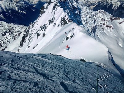
An early-spring snow climb of a prominent peak in the North Cascades. The Nohokomeen Headwall rises steeply above the Nohokomeen Glacier on Jack Mountain's northwest flank. Ascending the headwall involves climbing 700 vertical feet of snow at slopes up to 60°.
GETTING THERE
Drive SR-20, the North Cascades Highway, to the East Bank Trailhead (1,800 ft), near Milepost 138. Note that the western winter closure gate is at Milepost 134 (or possibly earlier), so climbing before the spring highway opening adds some extra miles.
APPROACH
Follow the East Bank Trail ~8 miles to the May Creek Campground. Head off trail and up ~3 miles to the toe of the Nohokomeen Glacier. Some of the route is steep and brushy. Either camp there or continue to the base of the headwall, camping anywhere along the way.
ASCENT ROUTE
Pick a line and ascend the headwall, which gets quite steep near the top. Later in the season the bergschrund may be an obstacle. Depending on the snow conditions, a rope and protection may be needed. Gain the ridge and traverse over to the summit, taking care to avoid cornices.
DESCENT
Descend the climbing route.
EQUIPMENT
Crampons and two tools. Rope and pickets. Snowshoes, depending on snow conditions.
NOTES
- This route is not described in the Cascade Alpine Guide, Vol 3, but it does contain good information about Jack Mountain.
- The trailhead and East Bank Trail are in the Ross Lake National Recreation Area, part of the North Cascades National Park. Jack Mountain and the Nohokomeen Glacier are in the Pasayten Wilderness, part of the Okanogan-Wenatchee National Forest.
- Suitable Activities: Climbing
- Climbing Category: Intermediate Alpine
- Seasons: March, April
- Weather: View weather forecast
- View avalanche forecast.
- Difficulty: Intermediate Mountaineering Climb
- Length: 30.0 mi
- Elevation Gain: 10,000 ft
- 9,066 ft
-
Land Manager:
Okanogan-Wenatchee National Forests
Pasayten Wilderness, Methow Valley Ranger District (OWNF)
- Parking Permit Required: None
- Recommended Party Size: 4
- Maximum Party Size: 12
- Maximum Route/Place Capacity: 12
- USGS Jack Mtn
- USGS Ross Dam
- USGS Crater Mountain
- USGS Pumkin Mtn
- Green Trails Mt Logan No. 49
- Green Trails Diablo Dam No. 48
- Green Trails Ross Lake No. 16
- Green Trails Jack Mountain No. 17
- Green Trails North Cascades Ross Lake No. 16SX
- Trails Illustrated North Cascades National Park
This is a list of titles that represent the variations of trips you can take at this route/place. This includes side trips, extensions and peak combinations. Not seeing a title that fits your trip? Log in and send us updates, images, or resources.
- Jack Mountain/Nohokomeen Glacier
- Jack Mountain/North Ridge
There are no resources for this route/place. Log in and send us updates, images, or resources.
