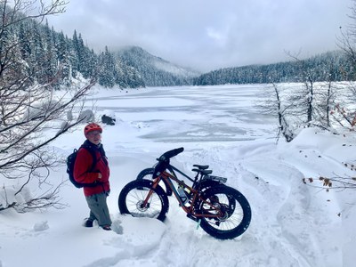
Lost Lake
A moderate to strenuous snowshoe trip with 800 feet of gain and 9 miles round trip on the east side of Snoqualmie Pass. When the skies are clear, enjoy views of Lake Keechelous on the way up to the lake, and Tinkham Peak is visible right across Lost Lake.
Getting There
Park at the at the Crystal Springs Sno-Park, Exit 62 off of I-90, east of Snoqualmie Pass.
Snowshoe Route
Follow Road 5480 as it first parallels Keechelus Lake, then climbs up the Roaring Creek drainage towards Lost Lake.
Bikepacking
From the Sno-Park travel northwest on the snowmobile trail that parallels the Palouse to Cascades Trail to Keechelus Dam, then take Forest Road 5480.
Notes
- In winter the road is generally groomed for snowmobiles.
- Snowmobile traffic is generally low on weekdays.
- Despite the short distance—a little over 5 miles each way—this is a moderately strenuous trip because of a gradual, but occasionally steep, 800-foot climb. Variable grooming conditions on the road in winter and heavier load on bikes may make it even more challenging. Expect to push your bike for some of the steeper sections of the road found near the lake.
Information for Leaders
Scheduling & Permits
- This route allows multiple bookings. Please check scheduled trips listed below in the "Activities" tab to see if there is another group already booked on the same day. Leaders are expected to contact the leader(s) of existing trips to ensure there are no concerns or conflicts, according to The Mountaineers Outdoor Ethics Policy. Please review our Group Size & Multiple Bookings page for guidance.
- Suitable Activities: Bikepacking, Cross-country Skiing, Snowshoeing
- Snowshoeing Category: Basic
- Seasons: January, February, March, December
- Weather: View weather forecast
- View avalanche forecast.
- Difficulty: Moderate/Strenuous, Bikepacking Gravel I, Bikepacking Gravel II, U-XC 2 Advanced Beginner Ungroomed
- Length: 9.0 mi
- Elevation Gain: 800 ft
- 3,100 ft
- Land Manager: Okanogan-Wenatchee National Forests
- Parking Permit Required: SnoPark Pass
- Recommended Party Size: 12
- Maximum Party Size: 12
- Maximum Route/Place Capacity: 12
- USGS Snoqualmie Pass
There are no resources for this route/place. Log in and send us updates, images, or resources.
