Lower Big Quilcene
An easy, 10 mile round trip day hike with 800 feet of elevation gain. The gentle trail follows the river up a valley with second growth forests.
getting there
From Quilcene, drive south on US-101 for 1.5 miles. Turn right onto Penny Creek Road, drive ~1.5 miles, and bear left onto Big Quilcene River Road (Forest Road 27). Stay right after ~3 miles, continuing on Forest Road 27, and after 0.5 mile, turn left onto Forest Road Spur 080, and continue to the trailhead.
on trail
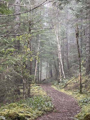
The Lower Big Quilcene Trail begins just outside the Buckhorn Wilderness and follows the lower Big Quilcene River along a mostly non-technical tread for approximately 6.5 miles. The moss-lined route starts on an old roadbed through younger forest and then winds past large old-growth cedars. In spring and summer, blooming rhododendrons add vibrant color to your journey. This trail is also a great choice during the fall and winter months because the trees provide shelter from precipitation.
At 2.7 miles from the trailhead, you’ll encounter the first established campsite, Bark Shanty. It is a large, level camping area nestled in a grove of big trees, right on the banks of the Big Quilcene River, with plenty of room for at least half-dozen tents."
Photo by Deni Mensing.
- Suitable Activities: Backpacking, Day Hiking, Trail Running
- Seasons: April, May, June, July, August, September, October, November
- Weather: View weather forecast
- Difficulty: Easy/Moderate
- Length: 10.0 mi
- Elevation Gain: 800 ft
- 2,000 ft
- Land Manager: Olympic National Forest
- Parking Permit Required: Northwest Forest Pass
- Recommended Party Size: 12
- Maximum Party Size: 12
- Maximum Route/Place Capacity: 12
- USGS Tyler Peak
- Green Trails Tyler Peak No. 136
This is a list of titles that represent the variations of trips you can take at this route/place. This includes side trips, extensions and peak combinations. Not seeing a title that fits your trip? Log in and send us updates, images, or resources.
- Bark Shanty
There are no resources for this route/place. Log in and send us updates, images, or resources.
