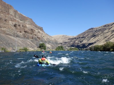
Deschutes River (Lower): Warm Springs to Columbia River
Packraft up to 95 miles of the lower Deschutes River, a designated Wild and Scenic River in north central Oregon.
FLOW
- USGS Gauge: Deschutes River at Moody, Near Biggs, OR
- NOAA Advanced Hydrologic Prediction Service: Deschutes River (OR) at Moody
- The lower Deschutes River has consistent flows and can be run year-round. Flows are typically 6,500 cfs through the winter and early spring and drop to 4,000 cfs in summer.
- The recommended range is 3,000 - 8,000 cfs.
Put-ins & Take-outs
The Deschutes River is divided into two sections by Sherars Falls, which is closed to boating. You can paddle the upper section, the lower section, or join the two with a portage around the Falls. Sandy Beach is the take-out above the falls and Buck Hollow the put-in below the falls.
Upper Section Put-ins
- A boat launch at Warm Springs State Recreation Area (River Mile 97.8) is at the upstream east end of the US-26 bridge across the Deschutes near Warm Springs. There is overnight camping at Mecca Flat, 1.8 miles downstream on river right.
- Trout Creek Campground (River Mile 88.4) is an alternate put-in.
- Additional put-ins and take-outs upstream of Maupin (River Mile 52) are reached by following the BLM access road from Maupin on the east side of the river and a for-fee take-out in Maupin City Park.
Upper Section take-out
- Sandy Beach day use area (River Mile 45.4) is the last take-out above the falls, a take-out immediately above the falls is closed to use.
Lower Section Put-ins
- Buck Hollow Launch Site (River Mile 42.8) is accessed by a gravel road that parallels the river to Mack’s Canyon Campground. This is the first put-in below Sherars Falls.
- Beavertail Campground (River Mile 31.4) is an alternative put-in farther down the road.
- Mack’s Canyon Campground (River Mile 23.9) is at the end of the gravel access road and the last put-in accessible from the south.
- Along the lower 20 river miles, the river can be accessed by foot or bicycle at a number of locations along the Deschutes River Trail, which begins in the Deschutes River State Recreation Area near the river’s mouth. While the trail continues upriver of River Mile 20 to connect with the access road ending at Mack’s Canyon, between about River Mile 20.1 and River Mile 23.8 there are some steep scrambles at several missing trestles, and numerous debris cones have built onto the trail, which make the biking and hike-a-bike slow and difficult. For locations of potential put-ins, see the Lower Deschutes Wild and Scenic River Maps 8, 9, and 10.
Lower Section Take-out
- Take out on river left at Heritage Landing (River Mile 0.3), just above the Deschutes’ confluence with the Columbia River.
ON THE RIVER
The lower Deschutes River is a great introduction to a multi-day desert river outing. It can be run year-round and permits are readily available with good planning. Train tracks run along the river but do not detract from the experience of a spectacular desert river.
There are numerous camps and pit toilets along the river. The BLM’s website has a digital map of campsites, launch sites, and toilets. There are some discrepancies between locations shown on the 2001 Boater’s Guide and current digital mapping layers.
Warm Springs to Sandy Beach (52.4 miles)
The section from Warm Springs to Sherars Falls has the most significant rapids—Whitehorse (River Mile 77) and Oak Spring (River Mile 47.5), both Class 3+ and three Class 3 rapids, Buckskin Mary (River Mile 64.3), Upper Wapinitia (River Mile 54.9) and Boxcar (River Mile 53.8).
Sandy Beach to Buck Hollow (2.6 miles)
This section of river is closed to boating. Hike the road or leave a car at Sandy Beach for the shuttle to Buck Hollow.
Buck Hollow to Heritage Landing (42.5 miles)
Downstream of Sherars Falls the river has five Class 3 rapids—Wreck Rapid (River Mile 39.5) near the start of the run—and four in the last 8 miles—Washout (River Mile 7.5), Gordon Ridge (River Mile 5.7), Colorado (River Mile 3.9), and Rattlesnake Rapids (River Mile 2.6). All can be scouted and portaged.
LOGISTICS
Permits
- Lower Deschutes River Boater Pass from recreation.gov
- Sandy Beach take-out: Permit from Confederated Tribes of Warm Springs
Guides, Maps & Online Resources
- The Deschutes River Boater's Guide (USDI Bureau of Land Management 2001) has river maps of the lower 100 miles of the river showing rapids, campgrounds, put-ins and take-outs, etc.
- Download the river maps from the Boater’s Guide without the narrative information from BLM’s website.
- Lower Deschutes River Back Country Byway BLM web page covering River Miles 61 to 19.
- American Whitewater describes the runs on two of its web pages, US 26 (Warm Springs) to Sherars Falls and Lower Deschutes, Sherars Falls to Columbia River.
Car Shuttles
- Sandy Beach to Warm Springs: 70 minutes
- Heritage Landing to Buck Hollow: 60 minutes
Alternate Bike-raft or Backpack Approach
The Deschutes River Trail from Deschutes State Recreation Area at the river’s mouth to RM 20.1 begins in crushed gravel and becomes increasingly coarse and angular with distance upriver. Between RM 20.1 and the access road at Mack’s Canyon the trail includes steep scrambles and considerable amount of strenuous hike-a-bike.
Water
River water can be filtered or water can be carried. Water can be obtained at Deschutes River Campground or Heritage Landing.
Human Waste
Human waste must be carried out. There are numerous pit toilets along the river.
- Suitable Activities: Packrafting
- Seasons: Year-round
- Weather: View weather forecast
- Difficulty: Class III+ River
- Length: 95.0 mi
- 1,380 ft
- Land Manager: Land Manager Varies
- Parking Permit Required: see Land Manager
- Recommended Party Size: 12
- Maximum Party Size: 12
- Maximum Route/Place Capacity: 12
- see Notes
There are no resources for this route/place. Log in and send us updates, images, or resources.
