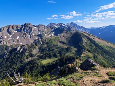
Marmot Pass & Buckhorn Mountain
One of the great Olympic hikes in the Buckhorn Wilderness. I takes you thru old growth forest along the pristine Big Quilcene River, then up out of the trees to to alpine meadows and views of snow-capped peaks to the south and sheer rock faces on the north. It's 10-13 miles round trip with 3,500 to 4,400 feet of elevation gain.
Getting There
From US-101, take Penny Creek Road for 1.5 miles and turn right onto Forest Road 27 (Big Quilcene River Road). In 9 miles, turn left onto Forest Road 2750 and follow it 5 miles to the trailhead.
on the trail
Marmot Pass (5,950 ft)
10.6 miles round trip, 3,500 feet of elevation gain
Hike the Upper Big Quilcene River Trail (No. 833.1) with a mostly moderate grade for the 5.3 miles and 3,500 feet of elevation to Marmot Pass (5,950 ft).
Buckhorn Mountain (6,996 ft)
12.6 miles round trip, 4,400 feet of elevation gain
Hike the steeper, rough, open path above the pass for a 1 mile and 900 feet of elevation gain to the top of Buckhorn Mountain (6,996 ft).
Information for Leaders
Scheduling & Permits
This route allows multiple bookings. Please check scheduled trips listed below in the "Activities" tab to see if there is another group already booked on the same day. Leaders are expected to contact the leader(s) of existing trips to ensure there are no concerns or conflicts, according to The Mountaineers Outdoor Ethics Policy. Please review our Group Size & Multiple Bookings page for guidance.
- Suitable Activities: Backpacking, Day Hiking, Trail Running
- Seasons: July, August, September, October, November
- Weather: View weather forecast
- Difficulty: Very Strenuous
- Length: 12.6 mi
- Elevation Gain: 4,400 ft
- 6,996 ft
-
Land Manager:
Olympic National Forest
Buckhorn Wilderness, Hood Canal Ranger District (ONF)
- Parking Permit Required: Northwest Forest Pass
- Recommended Party Size: 12
- Maximum Party Size: 12
- Maximum Route/Place Capacity: 12
- Custom Correct Buckhorn Wilderness
- Green Trails Tyler Peak No. 136
- Green Trails Olympic Mountains East No. 168S
- Trails Illustrated Olympic National Park
This is a list of titles that represent the variations of trips you can take at this route/place. This includes side trips, extensions and peak combinations. Not seeing a title that fits your trip? Log in and send us updates, images, or resources.
- Buckhorn Mountain
- Upper Big Quilcene to Marmot Pass
There are no resources for this route/place. Log in and send us updates, images, or resources.
