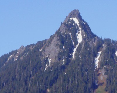
McClellan Butte
McClellan Butte is a scramble of 8 miles with 3,500 feet of gain near Snoqualmine Pass.
getting there
Take Exit 42 off of I-90 and head east on Forest Road 55 (West Tinkham Road) for 0.25 mile and turn right into the McClellan Butte trailhead parking lot (1,600 ft).
approach & ascent
Hike the McClellan Butte Trail for ~9 miles. When the trail ends, a short rock scramble leads to the summit and views of peaks in the I-90 corridor and Snoqualmie Pass.
information for leaders
Permits
As of 2017, the Snoqualmie Ranger District considers Mountaineers trips and courses to be "nominal use." Leaders should print and copy this designation letter to show rangers they may see on trail.
- Suitable Activities: Day Hiking, Scrambling
- Weather: View weather forecast
- Difficulty: Technical 3, Strenuous 3, Rock Scramble, Strenuous
- Length: 9.0 mi
- Elevation Gain: 3,700 ft
- 5,162 ft
-
Land Manager:
Mount Baker-Snoqualmie National Forest
Snoqualmie Ranger District (MBSNF)
- Parking Permit Required: Northwest Forest Pass
- Recommended Party Size: 12
- Maximum Party Size: 12
- Maximum Route/Place Capacity: 12
- Green Trails Mount Si NRCA No. 206S
- Green Trails Bandera No. 206
- USGS Bandera
There are no resources for this route/place. Log in and send us updates, images, or resources.
