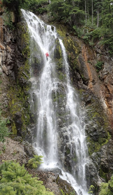
Mesatchee Creek
A tributary of the American River located east of Mount Rainier National Park in the Wenatchee National Forest. This rarely-run canyon features the scenic 150-foot Mesatchee Falls and 5 to 6 rappels. It is rated v3a3 III in mid-to-late summer.
GETTING THERE
From Chinook Pass, drive east on SR-410 E for 6.5 miles until reaching the Mesatchee Creek Trailhead on the right.
APPROACH
Follow the Mesatchee Creek Trail for 0.9 mile to a footbridge crossing Morse Creek. Turn left (south), and in 0.2 mile cross the American River. Hike 0.2 miles to a trail junction, bear left and head uphill for 0.5 mile to a viewpoint of Mesatchee Falls. Continue to follow switchbacks uphill for another 0.5 mile until the trail levels. At ~4,260 ft, leave the trail and descend steep slopes to the right into the creek. If you reach a small stream crossing, you've gone too far.
DESCENT
This canyon utilizes many natural anchors that can be damaged or washed away each season. Any group going through should be prepared to inspect and rebuild all anchors.
DCL = Down Canyon Left, DCR = Down Canyon Right
- Rappel 1: 25 feet from DCR tree
- Rappel 2: 60 feet from DCR tree
- Rappel 3: 80 feet from DCL tree
- Rappel 4: 15 feet from DCR tree
The next drop is Mesatchee Falls, a 150-foot waterfall, which can be completed in either one or two pitches. If rappelling from the top anchor in one pitch, rope retrieval may be difficult.
- Rappel 5: 20 feet from DCL tree to rebelay anchor off DCL tree (or, if completing in one pitch, 150 feet to the base of the falls)
- Rappel 6: 130 feet from DCL tree
EXIT
After the final rappel, walk downstream until the canyon opens up and it is possible to scramble up DCR slopes to the approach trail. Return to the trailhead the way you came.
EQUIPMENT
Standard canyoning gear including webbing, a wrench, and replacement quick links.
TRIP PROFILE
- Rappels: 5
- Longest Rappel: 150 feet
- Approach: 2.3 miles
- Exit: 1.8 miles
- Time: 4-6 hours total
NOTES
- This canyon is rated v3a3III from mid-to-late summer.
- For more information and recent trip reports from the community, visit the Mesatchee Creek listing on Ropewiki.
- Suitable Activities: Canyoning
- Seasons: June, July, August, September
- Weather: View weather forecast
- Difficulty: Moderate
- Length: 4.4 mi
- Elevation Gain: 800 ft
- 4,260 ft
-
Land Manager:
Okanogan-Wenatchee National Forests
Wenatchee River Ranger District (OWNF)
- Parking Permit Required: Northwest Forest Pass
- Recommended Party Size: 12
- Maximum Party Size: 12
- Maximum Route/Place Capacity: 12
There are no resources for this route/place. Log in and send us updates, images, or resources.
