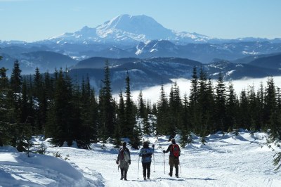
Microwave Hill (Keechelus Ridge)
A moderate snowshoe or ski trip up to a hill with a former radio tower and views of Lake Keechelus and Mount Rainier. Route options include taking Forest Service Road 4832 to Forest Service Road 124 to the top, or bushwhacking more directly to either Microwave Hill or the true summit from Road 124.
getting there
Now that the Price Creek Sno-Park has been permanently closed, the start of this route is the junction of Kachess Lake Road and Forest Road 4832. Take Exit 62 off of I-90 and head 1 mile north to the junction of Kachess Lake Road and Forest Road 4832. There is space for about 6 to 8 cars to park here, however, this area is not frequently plowed so be prepared for snow. An alternate parking option is ~0.7 mile north of I-90, near Exit 62 in a plowed pullout.
snowshoe route
Snowshoe 1.5 miles along the nearly flat Forest Road 4832, which parallels I-90. Turn right onto Forest Road 124 and follow this unplowed road up to where it crosses Forest Service Road 4934. Continue uphill until Forest Road 124 becomes Forest Road 126. Follow Forest Road 126 as it zigzags sharply before leading to the false summit (5,000 ft) with the former radio tower aptly named named, "Microwave Hill." This route is 6.5 miles one way to the top with nearly 3,000 feet of elevation gain. Microwave Hill is about half a mile west of the true summit (5,154 ft), which does not offer the same expansive views, so weary travelers can skip it without fear of missing out.
notes
- Since Forest Roads 124 and 126 zigzag up to Microwave Hill, more enterprising snowshoers and skiers can pick a more direct line to this sub-peak by bushwhacking.
- For an easy outing with little avalanche risk stay on Forest Road 4832 and the gentle slopes nearby.
- Microwave Hill tends to be popular with snowmobilers, because it can be reached via snowmobile-friendly trails. Forest Road 4832 is closed to wheeled traffic and groomed for snowmobiles west of the posted sign.
- The former Price Creek Sno-Park map is a good overview of the area.
- The flat part of Forest Road 4832 can be used for trail running on snow.
- Suitable Activities: Backcountry Skiing, Snowshoeing, Trail Running
- Snowshoeing Category: Intermediate
- Weather: View weather forecast
- View avalanche forecast.
- Difficulty: Strenuous
- Length: 12.0 mi
- Elevation Gain: 3,000 ft
- 5,000 ft
-
Land Manager:
Okanogan-Wenatchee National Forests
Cle Elum Ranger District (OWNF)
- Parking Permit Required: Northwest Forest Pass
- Recommended Party Size: 12
- Maximum Party Size: 12
- Maximum Route/Place Capacity: 12
- USGS Snoqualmie Pass
- Green Trails Snoqualmie Pass No. 207
This is a list of titles that represent the variations of trips you can take at this route/place. This includes side trips, extensions and peak combinations. Not seeing a title that fits your trip? Log in and send us updates, images, or resources.
- Forest Road 4832 (Keechelus Ridge)
There are no resources for this route/place. Log in and send us updates, images, or resources.
