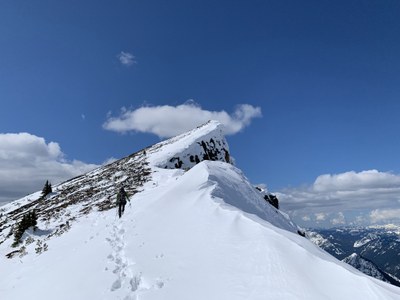
Middle Chiwaukum
A strenuous scramble a few miles east of Stevens Pass to a summit with outstanding views. It's 8 miles round trip and 4,800 feet of elevation gain.
getting there
Drive SR 2 to 13.5 miles east of Stevens Pass and turn south onto White Pine Road. Continue to the White Pine Trailhead at the road's end (2,800 ft).
In winter, park just outside the Cascade Meadows Baptist Church Camp and add 2 miles each way to walk the road to the trailhead.
approach & ascent
The approach is from Whitepine Creek Trailhead. After a short distance (~1/4 mile) on the trail, reach the ridge that trends southeast and ascend it all the way to Point 7132, then head south along the ridge to the Middle Chiwaukum summit (7,423 ft).
Notes
- SummitPost and PeakBagger call this "Middle Chiwaukum." It's labelled "Mcwaulum" on the Green Trails maps and is Point 7292 and not labelled on the USGS map.
- North Chiwaukum (aka Baldy) is an option to the north east.
- Suitable Activities: Scrambling
- Seasons: Year-round
- Weather: View weather forecast
- View avalanche forecast.
- Difficulty: Strenuous 5, Technical 3
- Length: 8.0 mi
- Elevation Gain: 4,800 ft
- 7,423 ft
-
Land Manager:
Okanogan-Wenatchee National Forests
Alpine Lakes Wilderness, Wenatchee River Ranger District (OWNF)
- Parking Permit Required: Northwest Forest Pass
- Recommended Party Size: 12
- Maximum Party Size: 12
- Maximum Route/Place Capacity: 12
- Green Trails Alpine Lakes East (Stuart Range) No. 208SX
- Green Trails Chiwaukum Mtns No. 177
- USGS Mt Howard
- USGS Chiwaukum Mountains
- Green Trails Alpine Lakes West (Stevens Pass) No. 176S
This is a list of titles that represent the variations of trips you can take at this route/place. This includes side trips, extensions and peak combinations. Not seeing a title that fits your trip? Log in and send us updates, images, or resources.
- Mcwaukum
- Mcwaukum & Baldy
- North & Middle Chiwaukum
There are no resources for this route/place. Log in and send us updates, images, or resources.
